Hurricane Lee Forecast to Make Landfall Saturday
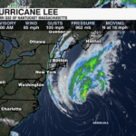

Hurricane Lee is a category 1 hurricane with maximum sustained winds of 80 mph. Lee is quickly moving north/northeast at 20 mph.
As of Friday evening, rainbands have started to move across Cape Cod and Nantucket as Lee inches closer to New England. Impacts will continue to spread across parts of the northeast overnight Friday through Saturday. Lee is forecast to slightly weaken just before landfall this weekend.
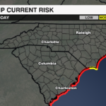
For the Carolinas, as Lee continues to push away, high seas, rough surf and a high rip current risk is likely as Lee passes well to our east.
PREVIOUS UPDATE: 8AM 9/15
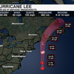
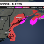
Hurricane Lee remains a category 1 hurricane as of the 8 am update from the National Hurricane Center. Hurricane Watches and Tropical Storm Warnings are in effect from New England to Atlantic Canada. Lee is located less than 460 miles from Nantucket and is moving north at 16 mph. Tropical storm conditions will begin across the northeast by this afternoon, with landfall near Nova Scotia on Saturday.

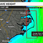
Lee is a very large storm with tropical storm-force winds outward up to 320 miles. The surf is rough off the Carolina Coast Friday morning with waves up to 10-15′. A high rip current risk remains in effect for much of the East Coast, including the Carolinas.

Hurricane Lee is picking up the pace and there is very little change in the strength of the storm through this evening. It will bring significant impacts to the New England and Canadian coast this weekend. The biggest threats for coastal communities include significant storm surge, coastal erosion, tropical storm force winds, rainfall totals of 1-4″ and a life-threatening rip current risk.

Get the latest information and updates on Lee and all the tropics by downloading the WCCB Weather App.
PREVIOUS UPDATE: 11PM 9/14
Hurricane Lee is roughly 170 miles west of Bermuda as of 11 PM Thursday. Lee is a category 1 hurricane with maximum sustained winds of 85 mph. 
Tropical Storm Warnings are in effect from Westport Massachusetts northward to the U.S./Canada border. Lee is large, therefore, impacts will be felt far from the center. Lee will arrive to the northeast this weekend bringing wind, rain, coastal erosion, high seas and rip currents. Storm Surge could reach 2-4′ in portions of southeastern Massachusetts, including Cape Cod and Nantucket late Friday and Saturday.

Impacts to the Carolinas: We will not see anything locally from Lee, but the coast is already seeing very dangerous rip currents.

PREVIOUS UPDATE: 9/14 8AM
Hurricane Lee continues to weaken, but impacts remain as the storm grows larger. As of the 8am update from the National Hurricane Center, Lee is a Category 2 Hurricane with sustained winds of 100 mph and gusts up to 120 mph.
It is located less than 300 miles from Bermuda. The island is under a Tropical Storm Warning as Lee will pass east of the country today. Tropical storm force winds, life-threatening surf and heavy rain are all threats for Bermuda Thursday.

The storm will pick up speed as it moves north through the Atlantic. It will weaken as it moves into cooler waters, however, this is a very large storm with tropical storm force winds extending more than 265 miles from the center and hurricane-force winds up to 115 miles from the center. It will only grow larger as it moves toward New England Friday.

Tropical Storm Watches are in effect from Cape Cod to Maine and a Hurricane Watch is in effect from Maine to Canada. Impacts will begin as early as Friday for Cape Cod with landfall near the Maine and Canadian border Saturday. Dangerous swells, life-threatening storm surge, beach erosion, damaging winds and flooding will all be concerns for the New England coast through the start of the weekend.

This storm is also causing indirect impacts along the east coast. Waves 10-15′ are possible off the coast of the Outer Banks Friday morning. A high rip current risk remains in effect for the Carolina coast through the start of the weekend.

Get the latest on Hurricane Lee by downloading the WCCB Weather App.
PREVIOUS UPDATE: 9/13 11PM
Hurricane Lee is a strong and large category 2 hurricane with 105 mph maximum sustained winds. Lee has now made that turn to the north as a trough digs across the eastern United States. Over the next few days, Lee will enter an environment with cooler waters and higher wind shear as it tracks north through the western Atlantic.
Tropical Storm Watches and Hurricane Watches are now in effect for portions of the New England and northeast coast.
Impacts to the Carolinas: We will not see anything locally from Lee, but the coast is already seeing very dangerous rip currents. Large waves of 4-6′ are also likely. Lee will pass well east of the Carolinas on Thursday and Friday.
Impacts to the Northeast: Lee is large, therefore, impacts will be felt far from the center. Lee will arrive to the northeast this weekend bringing wind, rain, coastal erosion, high seas and rip currents. Watches will likely be issued this evening.
PREVIOUS UPDATE 11AM 9/13
Hurricane Lee remains a major, Category 3 hurricane hurricane with sustained winds of 115 mph as of the 11 a.m. update from the National Hurricane Center. It will begin to make a more direct turn toward the north tonight. Lee will pass west of Bermuda on Thursday. It is forecast to pick up speed as it moves toward New England and Canada. Impacts for the parts of the northeast will begin as early as Friday evening.

A tropical storm warning is in effect for Bermuda and impacts from Lee will begin early Thursday for the island. Lee will pass just west of Bermuda on Thursday. Rainfall totals of 1-2″ are expected. Life-threatening swells and rip currents are likely for the island through Friday.

A high rip current risk is in effect for much of the East Coast, including the Carolina coast. Waves off the coast of the outer banks are forecast to reach 10-15 feet Friday morning.

Although Lee will weaken as it moves north into the cooler waters of the Atlantic, it will remain a very large storm. Currently, hurricane-force winds stretch as far as 115 miles from the center of Lee with tropical storm-force winds as far as 240 miles from the center.

The threat of heavy rain, tropical storm-force wind, and life-threatening surf is increasing for New England this weekend.
You can get the latest information on Hurricane Lee and the tropics by downloading the WCCB Weather App.
PREVIOUS UPDATE 11PM 9/12
As of 11 PM, Hurricane Lee is still a major category 3 hurricane with 115 mph maximum sustained winds. Over the next few days, Lee will enter an environment with cooler waters and higher wind shear. This will gradually weaken the storm.
The trough over the Midwest will arrive to the east coast by midweek. Lee will then turn northward. Lee will track hundreds of miles off the coast of the Carolinas late Thursday.
Impacts to the Carolinas: We will not see anything locally from Lee, but the coast will see very dangerous rip currents – especially through midweek. Large waves of 4-6′ are also likely. Lee will pass well east of the Carolinas.
Impacts to the Northeast: Coastal erosion, high seas and rip currents are likely. Damaging wind and rain possible. If Lee tracks a little west, impacts will be greater for parts of New England and Nova Scotia.
PREVIOUS UPDATE 11AM 9/12
As of the 11am update from the National Hurricane Center, Hurricane Lee has sustained winds of 115 mph. It remains a major Category 3 hurricane.

Some slow weakening is forecast within the next 48 hours, but the storm will remain large and dangerous as it begins to track to the north into the cooler waters of the Atlantic off the coast of the Carolinas – thanks to upwelling from Franklin and Idalia.
Bermuda has issued a Tropical Storm Watch as Lee will pass just west of the island Thursday. Outer rain bands will bring 1-2 inches of rain to Bermuda beginning Thursday into early Friday.

Although, Lee is forecast to weaken, it will remain a large storm as it bears down on the Northeast and Nova Scotia. It will likely make landfall late in the weekend over Canada, but due to the size of this storm, it will bring direct impacts with heavy rain, strong wind, and dangerous surf to parts of the New England by Saturday or Sunday.

The Carolinas won’t feel any direct impacts from the storm. But, life threatening rip currents and dangerous surf will begin impact the coast by mid-week. Hurricane force winds extend outward more than 90 miles and tropical storm force winds extend up to 205 miles.

Stay up to date on the very latest with Lee and the tropics by downloading the WCCB Weather App.
PREVIOUS UPDATE 11PM 9/11
Hurricane Lee is still a major category 3 hurricane with 115 mph maximum sustained winds. Lee has been undergoing an Eyewall Replacement Cycle which has very slightly weakened the storm.  Lee is forecast to enter a more favorable environment to further strengthen midweek.
The trough that is currently over the Midwest will arrive to the east coast by midweek. This will help Hurricane Lee make the northward turn.
Locally, Lee will pass well east of the Carolinas, but dangerous rip currents will dominate our coast through the second half of the week. Parts of New England and Canada will likely see impacts this weekend.
PREVIOUS UPDATE 5AM 9/11
Hurricane Lee has battled stronger shear over the last few days. But, it is now on track to strengthen back into a Category 4 over the next 12-24 hours.

As of the 5 am update from the National Hurricane Center Lee has sustained winds of 120 mph with gusts upwards of 150 mph. Lee is a major Category 3 hurricane. Although the center of the storm has become a bit less distinct, new convection is wrapping around the western portion of the eyewall. This is a very large storm with hurricane force wind expanding 85 miles and tropical storm force winds expanding up to 185 miles from center.

Lee’s trajectory keeps it north of the Caribbean. It has been guided by a ridge to the north. A trough moving off the east coast will help guide the storm to the north. It will slow and weaken as it moves into cooler waters. The storm will pass just to the west of Bermuda late this week. From there, it is still uncertain if Lee will have any direct impacts with the northeast or Canada. However, the storm will be very large, and impacts to parts of New England and Canada are looking more likely late this weekend.

Locally, Lee will stay far away from the Carolinas. However, this storm will be producing significant swells and a dangerous rip current risk will begin late mid to late week.
Get the latest updates on Hurricane Lee and all the tropics by downloading the WCCB Weather App.
PREVIOUS UPDATE 5AM 9/7
5 AM ET Update: Hurricane Lee is a powerful Category 5 storm that is expected to strengthen Friday. Sustained wind speeds are currently 165 mph. The storm is east of the Caribbean. Lee’s core is expected to move well north of the northern Leeward Islands, the Virgin Islands, and Puerto Rico this weekend and early next week.

Dangerous surf and life-threatening rip currents are likely in the northern Leeward Islands beginning later today. These conditions will spread westward and northward, affecting Puerto Rico, Hispaniola, the Turks and Caicos, the Bahamas, and Bermuda through the weekend.
It is way too soon to know what level of impacts, if any, Lee might have along the U.S. East Coast, Atlantic Canada, or Bermuda late next week, particularly since the hurricane is expected to slow down considerably over the southwestern Atlantic. Regardless, dangerous surf and rip currents are expected along most of the U.S. East Coast beginning Sunday.
11 PM ET Update: Lee is a beast and is now a category 5 hurricane with maximum sustained winds up to 160 mph. Strengthening will continue.
Hurricane Lee is 705 miles east of the northern Leeward Islands and is moving west/northwest at 14 mph.
Hurricane Lee is forecast to reach a max intensity of 180 mph. Only seven hurricanes in the Atlantic have has winds equal to or greater than 180 mph.
Models continue to show a turn to the north midweek next week. This is due to a stronger trough over the east coast and a weakening ridge of high pressure offshore. Confidence is growing that Lee will pass east of the east coast late next week, but this forecast is not etched in stone. We still need to watch it closely.
For the latest updates on the tropics and Hurricane Lee download the WCCB Weather App.
PREVIOUS UPDATE 5AM 9/6
As of the 5AM update from the National Hurricane Center, Hurricane Lee stayed in a steady state overnight. The storm is producing sustained winds are at 80 mph with stronger gusts up to 110 mph.

It is on track to begin rapidly intensifying today and is forecast to become a major hurricane by Friday morning.

Hurricane Lee is moving to the WNW at 13 mph. It is located less than 1,000 miles from the Northern Leeward Islands. It is still on track to stay to the north of the Leeward Islands, Puerto Rico and the Dominican Republic this weekend. Although, strong swells that can cause life threatening surf and rip currents are forecast to reach portions of the Lesser Antilles Friday and the Virgin Islands, Puerto Rico, Hispaniola, the Bahamas and the British Virgin Islands this weekend.
Without any direct land interaction and weakening shear, Hurricane Lee will rapidly intensify this weekend as it moves through warm ocean waters in the Atlantic. It will become a very large and dangerous hurricane, peaking near Category 5 strength by Saturday and Sunday.

The storm’s trajectory is guided by the large tropical ridge, keeping it north of the Leeward Islands. However, it is still on track to steer to the north by the middle part of next week as a trough moves off the east coast. Still, due to the size and strength of the storm and the uncertainties of the strength of the trough we will need to watch this storm very closely next week.
For the latest updates on the tropics and Hurricane Lee download the WCCB Weather App.
PREVIOUS UPDATE 11PM 9/6
Lee is now a hurricane with maximum sustained winds of 80 mph as of 11 PM Wednesday. This storm is moving quickly to the west/northwest at 14 mph.
Lee is currently just over 1,000 miles east of the Leeward Islands. As its westward track continues, this storm is forecast to rapidly strengthen into a major hurricane by this weekend.
Most computer models are still in agreement showing this system curving into the Atlantic. The track will depend on steering currents – a trough across the East Coast and a ridge of high pressure in the Atlantic. How strong these two things are will depict the future track of Lee. That being said, it is too soon to write this one off. We will watch closely.
Download the WCCB Weather App for the latest updates on tropics and the latest on your local forecast.
PREVIOUS UPDATE 11AM 9/6
Tropical Storm Lee continues to strengthen in the Central Atlantic as of the 11am update from the National Hurricane Center.

The storm is near hurricane strength with sustained winds of 70 mph. Pressure is also falling and is now down to 994 mb, which also signals the storm is strengthening. It is battling some low level shear that will be decreasing over the next 24 hours. It is forecast to intensify rapidly as it moves through above-average ocean temps in the range of 84-86F. It will likely become a hurricane by this evening and a major hurricane by the end of the week, or the start of the weekend.

Lee is located about 1200 miles east of the Northern Leeward Islands and is moving toward the west-northwest at 14 mph. Lee will stay on this track over the next few days as a ridge holds to the north of the storm, guiding its movement. The current trajectory would keep the storm just north of the Leeward Islands in the next 3-4 days.

From there, model consensus has Lee recurving to the north as a trough directs the storm away from the southeast coast. This will still be something that needs to be monitored as the timing of the track and strength of the trough could have some impact on the trajectory of the storm.
Keep up with the very latest from the WeatherWise team on Tropical Storm Lee by downloading the WCCB Weather App.
PREVIOUS UPDATE 11PM 9/5
Tropical Storm Lee has formed in the Central Atlantic. As of 11 PM, Lee has winds of 50 mph and is moving WNW at 16 mph. Lee is forecast to quickly strengthen into a major hurricane by this weekend.
Most computer models show this system curving into the Atlantic which is a good sight to see as a trough dips across the East Coast. That being said, it is too soon to write this one off. It is still far out so needs to be watched closely.
Download the WCCB Weather App for the latest updates on tropics and the latest on your local forecast.
PREVIOUS UPDATE 11AM 9/5
Tropical Depression 13 has formed in the Central Atlantic. It is located about 1400 miles to the east of the Lesser Antilles. It has sustained winds of 35 mph and is moving to the WNW at 15 mph.

The National Hurricane Center is forecasting that this system will become a tropical storm within the next 12-24 hours. The next name on the 2023 Atlantic Hurricane Basin list is Lee.
TD 13 will move into an environment that will aid in rapid development. It will likely become a hurricane by the end of the week and it is forecast to strengthen into a major hurricane by teh ned of the weekend. Sea surface temperatures are well above average and wind shear is minimal as it tracks toward the Leeward Islands. It is forecast to become a hurricane within a few days and a major hurricane by the end of the week.

Will this storm impact the East Coast?
As of now, model trends have this storm turning north as it approaches the southeast early next week. A trough will help guide the storm to the north. However, it is far too early to not have any concerns about this storm. If this storm does not strengthen as quickly as it is forecast it may not turn as quickly to the north. It will be something to watch closely over the next week.
Download the WCCB Weather App for the latest updates on tropics and the latest on your local forecast.
PREVIOUS UPDATE 10PM 9/4
WCCB Charlotte’s weather team is keeping a close eye on ‘Invest 95L’ which is currently between the Lesser Antilles and Africa.
With warm waters and low wind shear, environmental and atmospheric conditions are conducive for development. The National Hurricane Center has now increased the chance for development to 100%.
In terms of intensity, both the GFS (American) and the European models show this becoming a major hurricane in the Atlantic Ocean.
It is still too early to know where this system will go, but models do show a northward turn before reaching the United States. That is not set in stone though! IF this system did reach the United States, it is still 10-12 days away.
This week, no tropical systems will impact the United States!


