Philippe Is Now A Post-Tropical Cyclone
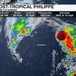
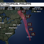
Philippe is now a Post-Tropical Cyclone. Philippe spent 14 days as a tropical storm. Philippe is still expected to impact parts of New England and Atlantic Canada this weekend with heavy rain and strong wind.
 The National Hurricane Center will no longer be issuing advisories on this storm.
Previous Update 5am 10/6
Tropical Storm Philippe is nearing Bermuda as of the 5am update from the National Hurricane Center. A Tropical Storm Warning is in effect for Bermuda with tropical storm conditions beginning and continuing through Friday.

The storm remains very disorganized with sustained winds of 50 mph. It is moving quickly to the north-northeast at 18 mph. It is then forecast to make a turn to the north and race toward New England this weekend. By Saturday the storm will be post-tropical.

Rainfall totals of 1-3″ are possible for Bermuda today. New England and Atlantic Canada could see 1-3″ of rain with local amounts up to 5″ possible. Flash flooding is expected. There will also be an increased rip current risk along the northeast coast through the weekend.
Previous Update 11pm 10/5
Tropical Storm Philippe is moving north near 16 mph and has maximum sustained winds of 50 mph. Philippe is forecast to track near Bermuda on Friday where there are Tropical Storm Warnings in effect.
 This weekend, Philippe is forecast to become a non-tropical system as it heads toward the northeast. Tropical or not, parts of the northeast and Atlantic Canada will see heavy rain and gusty wind.
PREVIOUS UPDATE 10/4 11PM
Philippe is holding onto tropical storm force strength at 40 mph. This struggling storm is moving north near 13 mph. Philippe is forecast to track near Bermuda Thursday night and Friday. There are Tropical Storm Warnings issued for Bermuda.
 This weekend, Philippe is forecast to become a non-tropical system as it heads toward the northeast. Tropical or not, those in the northeast and Atlantic Canada should monitor this storm. There will be no direct impacts to the Carolinas.
PREVIOUS UPDATE 10/4 5AM
Tropical Storm Philippe remains disorganized as it slowly moves northwestward. It will continue to bring heavy rain and potential flooding to the Virgin Islands today.

As of the 5am update from the National Hurricane Center, there are no active watches or warnings for the Caribbean as the center of Philippe sits north of the islands. Winds are sustained at 45 mph with gusts up to 60 mph. There is little change in strength over the next day or so. However, some gradual intensification will be possible later in the week as the storm moves back over the open Atlantic.
Rainfall totals of 4-8″ still possible across the Virgin Islands today with 2-4″ across Puerto Rico.

Tropical Storm Philippe will approach Bermuda by late week, before eyeing Maine and Canada late in the weekend. This track has changed quite a bit over the last week, so it will be something to continue to watch over the next few days.
PREVIOUS UPDATE 10/3 5PM
Tropical Storm Philippe is passing by the British Virgin Islands this afternoon. Maximum sustained winds are down to 45 mph as Philippe moves northwest at 12 mph.
Gusty winds and heavy rain will continue across portions of the northern Leeward Islands and the British Virgin Islands through Wednesday. As this system tracks northward, the chance of tropical storm conditions impacting Bermuda later this week are increasing. 
As of Tuesday evening, there has been a shift westward in Philippe’s track. This puts Atlantic Canada and eastern New England in the “cone of uncertainty” this weekend. Those in the northeast should monitor the progress of this storm.
PREVIOUS UPDATE 8AM 10/3
Tropical Storm Philippe made landfall in Barbuda Monday. It continues to bring heavy rain and the threat of flash flooding, dangerous surf and tropical storm force winds to the Northern Leeward and Windward Islands.

As of the 8am update from the National Hurricane Center, Philippe has sustained winds of 50 mph. It is located 40 miles northwest of Anguilla. It is moving to the northwest at 10 mph.
Tropical Storm Philippe is forecast to continue moving to the northwest today, before making a turn to the north-northwest tonight. It will then take on a northward motion on Wednesday. It will move north of the Leeward Islands today.

The strongest wind and heaviest rain will likely occur in the islands to the south of center. A Tropical Storm Warning remains in effect for Barbuda and Anguilla. A Tropical Storm Watch is in effect for the British Virgin Islands.

Flash flooding is a top concern with this storm. Philippe is forecast to produce 4-8″ of rainfall for Barbuda southward to Dominca. The rest of the Leeward Islands and northern Windward Islands could receive 3-5″ of rainfall with the Virgin Islands receiving 1-3″ of rain.
PREVIOUS UPDATE 11PM 10/2
Tropical Storm Philippe is 70 miles east/southeast of St. Martin as of Monday evening. Maximum sustained winds are at 50 mph. Philippe is bringing heavy rain and scattered flooding to portions of the northern Leeward Islands. The flooding threat will continue through Tuesday.
Little change in intensity is likely over the next couple of days. Later this week, Philippe will enter more favorable environmental conditions which may allow the storm to strengthen into a hurricane. This is no threat to the United States.
PREVIOUS UPDATE 5AM 10/02
Tropical Storm Philippe continues to slowly move toward the Northern Leeward Islands. Philippe is located 125 miles to the east-southeast of Barbuda. It is moving to the northwest at 7 mph. Impacts across the Northern Leeward Islands will begin today. A Tropical Storm Watch is in effect for Antigua and Barbuda.

Dangerous surf, tropical storm-force winds, and heavy rain leading to flash flooding will be possible for the Northern Leeward Islands. Rainfall totals of 4-6″ is expected for for Antigua and Barbuda and up to 2-4″ will be possible for other areas across the Northern Leeward Islands.

Although there hasn’t been much of a change in intensity over the last few days, the storm has fought off higher shear and will begin to take a sharper turn to the north where it will enter into a more favorable environment. Philippe is now forecast to become a hurricane by the end of the week.

Although the forecast intensity of the storm is trending stronger later this week, the track will keep the storm away from the US mainland.
PREVIOUS UPDATE 8AM 9/29
Despite the high shear and dry environment, Tropical Storm Philippe has continued to hang on. It remains a little more than 500 miles to the east of the Northern Leeward Islands. Sustained winds are 45 mph with gusts upwards of 60 mph.

Philippe won’t move much over the weekend. Instead, it will meander east of the Greater Antilles. This is good news, because it means the latest track keeps the storm from bringing direct impacts to the islands.

Philippe may strengthen slightly this weekend before taking a turn to the north early next week. It is projected to take a turn to the north early next week.
The storm is forecast to remain tropical through the weekend. There is no threat to the U.S. Mainland.
PREVIOUS UPDATE 11PM 9/27
Tropical Storm Philippe is a little stronger with maximum sustained winds of 50 mph. Philippe is moving NW at 8 mph. By this weekend, Philippe is forecast to downgrade to a Tropical Depression before reaching Puerto Rico. Thankfully, Philippe is no threat to the United States.
PREVIOUS UPDATE 11PM 9/27
Tropical Storm Philippe is now located less than 700 miles east of the Northern Leeward Islands. It is disorganized with thunderstorms well east of center.

Philippe has sustained winds of 45 mph. It will continue to weaken over the next few days and is forecast to become a remnant low by the end of the week — if not sooner. The storm is battling a high-shear environment and is choking on drier air as it continues its push to the west.
The track of this storm has once again shifted to the south with heavy rain and gusty winds possible for Puerto Rico by the weekend. No watches or warnings have been issued at this time.
There is no threat to the US mainland.
PREVIOUS UPDATE 11PM 9/27
Tropical Storm Philippe is roughly 730 miles east of the Northern Leeward Islands as of 11 PM Tuesday.
Philippe is expected to slowly weaken over the next several days as it continues tracking west.
Tropical storm force winds extend outward up to 230 miles from the center of the storm. Thankfully, Philippe is no threat to the United States.
PREVIOUS UPDATE 8AM 9/26
Tropical Storm Philippe remains disorganized this morning. It has been battling higher shear and will be moving into a drier environment. The storm will struggle and gradually weaken without any direct land interaction.

Sustained winds are at 50 mph with gusts up to 65 mph. It is moving to the west-northwest at 13 mph. It is not forecast to strengthen much from this point. And the general track of the storm will continue in this direction through the weekend.

Philippe is now forecast to become a remnant low this weekend while staying north of the Caribbean.
PREVIOUS UPDATE 8AM 9/26
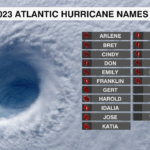
Tropical Storm Philippe is the 17th storm of the 2023 Atlantic Hurricane Season. It is located more than 1000 miles to the east of the Northern Leeward Islands. As of the 11pm update from the National Hurricane Center, it is moving to the west/northwest at 12 mph. It will take more of a northwestward track in a few days — staying away from land and over the Central Atlantic through the start of the weekend.
Philippe has sustained winds at 50 mph with slightly stronger gusts. Tropical Storm force winds extend outward up to 115 miles from the center of the storm. It is not forecast to strengthen much over the next few days as it battles moderate wind shear. The storm will continue to struggle late in the week as it moves into drier air and encounters even higher shear.
Unlike Ophelia, which made landfall as a tropical storm early Saturday morning near Emerald Isle, NC, this storm is not a threat to the US mainland.
A little more than 30% of hurricane season remains. There are two more areas to watch in the Atlantic. Including an area of low pressure in the Eastern Atlantic that will likely become a tropical depression within the next few days.

Get the latest information on the tropics by downloading the WCCB Weather App.


