Hurricane Tammy Continues to Bring Impacts to Leeward Islands
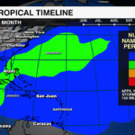
Tammy strengthened into a hurricane late last week. It was the 6th hurricane of the 2023 Atlantic Hurricane Season. It took aim at the Leeward Islands dropping heavy rain, and triggering flash flooding as more than 8 inches fell over the course of just a few days. The storm made landfall in Barbuda Sunday as a category 1 hurricane.

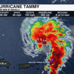
Hurricane Tammy is located more than 200 miles north-northwest of Anguilla. The storm has sustained winds of 90 mph with gusts of 100mph. It is moving toward the north at 10 mph. It will take a turn to the north-northeast over the next few days. It will strengthen slightly but remain at category 1 strength through mid-week before weakening into a post-tropical storm this weekend.

An additional 1-3 inches of rain is expected across the British Virgin Islands and Leeward Islands. This would bring rainfall totals to more than a foot over parts of the islands. The additional rainfall could lead to more flash flooding and mudslides on the higher terrain. Dangerous rip currents will continue over the next few days for the Leeward Islands, British and US Virgin Islands, and Puerto Rico.
There is no direct threat to the US mainland at this time.
PREVIOUS UPDATE 5AM 10/20
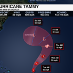
Tropical Storm Tammy continues to intensify as it moves closer to the Leeward Islands. As of the 5am update from the National Hurricane Center, Tammy is located less than 100 miles from Barbados. It is moving to the west-northwest at 8 mph.

Hurricane Watches and Tropical Storm Warnings are in effect for parts of the Caribbean ahead of Tropical Storm Tammy. Tropical Storm conditions will begin later today. Hurricane conditions are possible in portions of the Leeward Islands tonight and Saturday.

Rainfall totals 4-8″ with up to a foot possible for the Leeward Islands. This could lead to isolated flash and urban flooding as well as mudslides for the higher terrain. Storm surge of 1-3′ will be possible as well as dangerous rip currents through the start of the weekend.

Tammy will strengthen into a hurricane over the warmer waters of the Caribbean within the next 24 to 36 hours before moving toward the north and then the northeast this weekend. There is no threat to the US East coast at this time.
PREVIOUS UPDATE: 8PM 10/19
Tropical Storm Tammy is slowing down as it approaches the Leeward Islands. Maximum sustained winds are up to 60 mph.
 Tropical Storm conditions and heavy rain are expected to begin on Friday.
As Tammy moves over the northern Leeward Islands on Saturday, it is forecast to become a category 1 hurricane. After moving over or close to the islands, this system will turn north and head out to sea. Tammy is no threat to the United States.
A Hurricane Watch is in effect for Guadeloupe, Antigua, Barbuda, Montserrat, St. Kitts and Nevis.

PREVIOUS UPDATE 5AM 10/19
As of the 5 am update from the National Hurricane Center, Tammy is located less than 500 miles from Guadeloupe with sustained winds of 40 mph. The storm is moving to the west at 17 mph and is expected to strengthen over the next few days.
Tropical Storm Tammy will take a turn toward the west-northwest tonight, followed by a turn to the northwest Friday. The center of Tammy will move near or over the Leeward Islands on Friday and Saturday. Tammy will then be steered to the northeast by a ridge in the Atlantic and an approaching trough off the U.S. East Coast. This will keep the storm away from the U.S. mainland.
Although Tammy will continue to battle moderate shear, the warmer sea surface temperatures near the Leeward Islands will help fuel the storm. Tammy could be near hurricane intensity by the end of the weekend.
Tropical Storm conditions will impact portions of the Lesser Antilles starting Friday. The following locations are now under a Tropical Storm Watch: Barbados, Dominica, Martinique & Guadeloupe, Antigua, Barbuda, Montserrat, St. Kitts & Nevis.
Rainfall totals of 3-6″ are likely with up to 10″ possible across northern portions of the northern Windward Islands into the Leeward Islands. Rainfall totals of 1-2″ with up to 4″ expected for the British and US Virgin Islands and eastern Puerto Rico.
Threats include isolated flash and urban flooding as well as isolated mudslides across areas of higher terrain. Dangerous swells will also likely cause life-threatening surf and rip current risks.
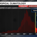
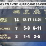
Tropical Storm Tammy is the 20th storm of the 2023 Atlantic Hurricane Season. If it becomes a hurricane it would be the 7th of the season. The 2023 Atlantic Hurricane Season ends November 30.
PREVIOUS UPDATE 5PM 10/18
Tropical Storm Tammy has formed east of the Lesser Antilles. Tammy has maximum sustained winds of 40 mph and is moving west at 23 mph.
Impacts will begin for the Lesser Antilles on Friday and continue through the first half of the weekend. After impacting the islands, Tammy will turn north and move out over the Atlantic Ocean. This system is not a threat to the United States.
UPDATE: 2AM 10/18
Invest 94-L is located in the Central Atlantic, several hundred miles east of the Lesser Antilles. Environmental conditions will remain conducive for gradual development. A tropical depression or storm is likely to form within the next day or two while the system moves westward.

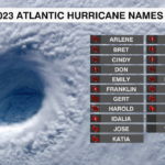
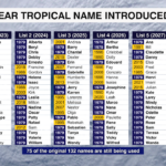
The next name on the 2023 Atlantic Hurricane Name list is Tammy. Tammy remains one of 75 of the original 132 names that is still being used since it was originally introduced in 1979. There is a little more than 10% of hurricane season remaining. If this system does become Tammy it would be the 20th storm of the season.

Regardless of development, this system will bring gusty wind, heavy rain and dangerous rip currents to the Lesser Antilles by Friday.


