Cool & Sunny Sunday
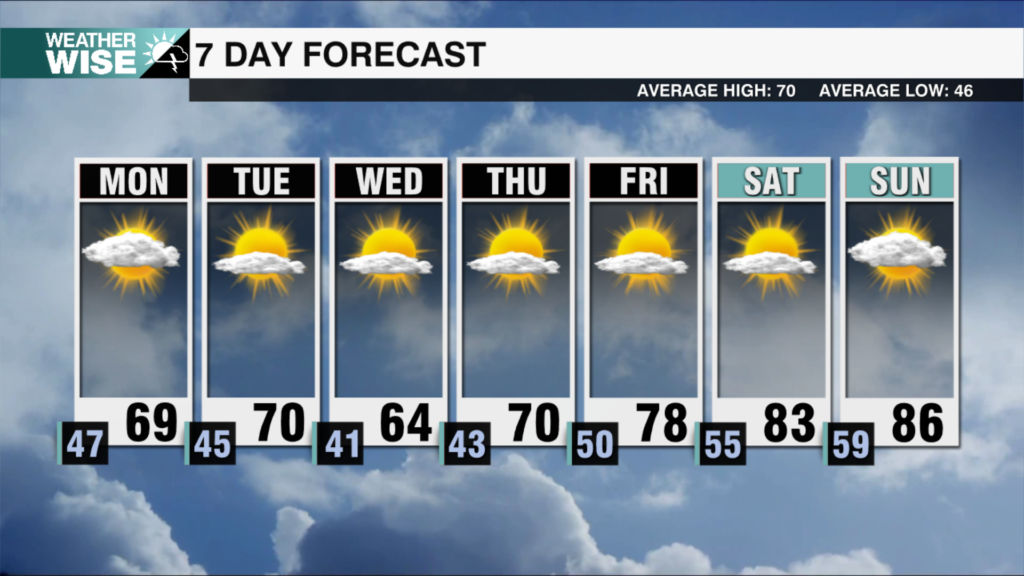
Temperatures quickly recover into the heart of March as highs swell well into the 70s.
The rain has largely slid out of the WCCB Charlotte viewing area this Saturday evening, leaving us with a dry and cloudy start to the night. Expect scattered clouds to gradually dwindle in number from west to east overnight as northwesterly flow leads to a few snow flurries in the High Country. Most of us will wake up to abundant sunshine Sunday morning. Despite the sunny skies, highs will struggle to clear the 40s and 50s as a cooler air mass settles over the Carolinas to close out the weekend. Patchy frost is possible overnight into Monday; lows will bottom out in the 20s and 30s to kick off the workweek.
The week ahead starts off on a chilly note, but temperatures quickly recover. Highs will return to the 60s for most across the Piedmont and Foothills on Monday. We’ll likely crack the 70s by Wednesday as the sunshine teams up with more southerly winds. The warmest air we’ve seen all year may arrive on Thursday and Friday, topping out in the mid-to-upper 70s before another rainmaking system brings cooler air into the weekend. Shower chances appear few and far between through Thursday.
Tonight: Clouds peel away. Much cooler. Low: 42°. Wind: NW 5-15.
Sunday: Cool sunshine. Breezy. High: 58°. Wind: NW 10-20. Gusts: 25+
Sunday Night: Clear and cold. Frost likely. Low: 32°. Wind: NW 5-15.
Monday: Sunshine continues. Warmer. High: 63°. Wind: NW 5-15.