WeatherWise Alert: Strong to Severe Storms Possible Overnight
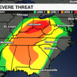
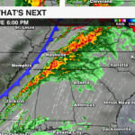
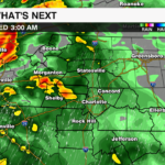
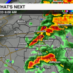
As we begin the month of April, we also enter into peak severe weather season for the Carolinas. A severe weather outbreak is possible today pver the Ohio Valley with a broader severe weather threat across the southeast. A cold front associated with a potent low pressure system will bring the threat of severe weather to the region overnight into early Wednesday morning. Although the severe threat will be somewhat limited due to the timing of the cold front entering into the Carolinas, there will likely be enough intensity remaining from a few of these thunderstorms that an isolated severe threat will still be possible.
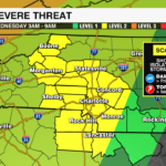
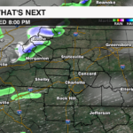
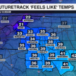
The Storm Prediction Center has expanded the level 2 severe threat to include areas east of I-77 overnight. Damaging straight line wind gusts will be the greatest threat, however, isolated tornadoes and localized flooding will also be possible. Once the front clears the region early Wednesday morning, much colder air will slide into the region with gusty winds and a light accumulation of snow possible for the mountains.
WHAT: Scattered strong to severe storms ahead of a cold front move into the Carolinas overnight bringing the threat of severe weather.
WHEN: 3AM – 9AM Wednesday
WHERE: Areawide.
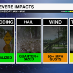
THREATS:
- Damaging Straight Line Winds (Primary)
- Isolated Tornadoes
- Localized Flooding (Generally for the Mountains)
It is important you have multiple ways to receive weather alerts, especially with an overnight/early morning severe threat. Download the WCCB Weather App and make sure your notifications are turned on. We will bring you updates throughout the evening of the changing weather and if any warnings are issued for your area you will be immediately notified.


