WeatherWise Alert: Severe Threat Increases Wednesday Afternoon
WeatherWise Alert 2-3 Rounds of Strong to Severe Storms Possible
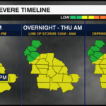
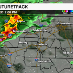
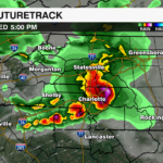
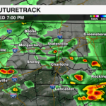
Round #1 Afternoon: 2-8pm: Scattered Storms, Supercells Possible
Threats:
-
-
- Damaging Wind Gusts 60+ mph
- Large Hail Quarter to Ping Pong Sized
- Isolated Tornadoes
-
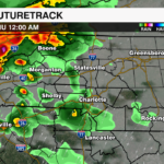
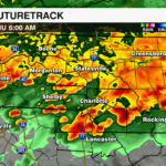
Round #2 Overnight – Thu AM: 12AM – 8AM: Line of Storms, Discrete Cells Possible
Threats:
- Damaging Wind Gusts
- Isolated Tornadoes
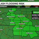
- Localized Flooding
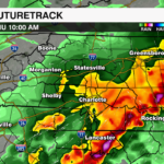
Round #3 Thursday PM: Depends on morning storm coverage
Threats:
- South of I-85 for Development
- Damaging Wind Gusts
- Localized Flooding
- Isolated Tornadoes
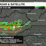
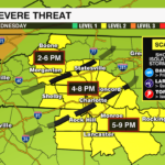
Severe Threat #1
Ongoing thunderstorms over the TN/KY border will move into a juicy environment over the Carolinas this afternoon where we will likely see some intensification and development of storms moving south and east through the early evening. Temps will warm into the upper 80s to lower 90s with plenty of moisture flowing into the region from the Gulf to provide fuel for storms. We’ll get breaks in the cloud cover allowing temps to heat up quickly and deep layer shear to keep these storms going Damaging wind, large hail and isolated tornadoes will be the main threats as these storms will race through the region. As of now, low level shear is lacking which is keeping our tornado threat low, but again not zero as we will need to watch for any discreet cells ahead of the pack. Some of the strongest storms and highest severe threat will be during the evening commute. Stay weatherwise this afternoon and evening.
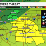
Severe Threat #2
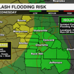
After midnight, ahead of the cold front we will likely see more of a line of storms progress through the region. The cold front will act a trigger for these storms, so we need to watch for any cells ahead of the line that could rotate. Otherwise, damaging winds and heavy rain leading to localized flooding will be the biggest concerns through Thursday morning as the front slows and meanders through the region through the morning commute.
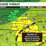
Severe Threat #3
If there is a break in the cloud cover or storms fizzle Thursday morning. We will likely see storms fire up again Thursday afternoon with that severe threat highlighted near and east of I-85.
A few showers may linger through early Friday as the front lingers near the region. However, drier air and cooler temps will arrive just in time for the weekend.
Download the WCCB Weather App for all the latest alerts and updates on the severe threat.


