Category 2 Hurricane Francine Made Landfall In Terrebonne Parish, Louisiana
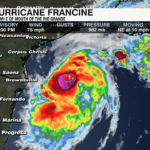
Hurricane Francine strengthened to a category 2 hurricane an hour before making landfall in Terrebonne Parish, Louisiana. Life-threatening storm surge and hurricane force winds will continue through the evening into Wednesday night.
Since 2000, there have been 7 category 2+ hurricanes that have made landfall along the Louisiana coast. The latest being hurricane Ida which was a category 4 hurricane in 2021.
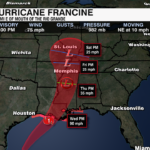
Francine Impacts To The Carolinas:
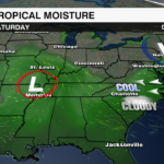
RAIN: The western Carolinas will likely see the highest rain totals.
- East of I-77 could see 0.5”-1”
- West of I-77: 1-2”
- Western North Carolina: 2-4”
TIMING: Thursday PM/Overnight – Sunday.
Any impacts we see will be indirect – due to the counterclockwise rotation around Francine, Atlantic moisture will wrap around the low pressure.
Elsewhere In The Tropics:
Tropical Depression Seven is forecast to become Tropical Storm tonight or Thursday
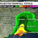
Previous Update 9/10 — 8 PM
Francine is now a hurricane and continues to strengthen in the Gulf of Mexico. Landfall along the Louisiana Coast will be on Wednesday. 
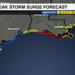
Flooding is the #1 threat due to rainfall and storm surge along parts of the northern Gulf Coast. 5-10 foot storm surge is possible along parts of the LA coast + 4-8 inches of rain. Isolated 12 inches+ are possible.
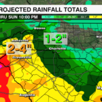
Francine Impacts To The Carolinas:
Any impacts we see will be indirect due to the counterclockwise rotation around Francine.
Timing: Thursday PM through Saturday
Rain Totals:
– East of I-77 could see 0.25”-1”
– West of I-77: 1-2”
– Western North Carolina: 2-4”
PREVIOUS UPDATE 9/10 AM
Tropical Storm Francine is continuing to organize as it moves across the Western Gulf of Mexico. The storm is expected to strengthen into a hurricane within the next 24 hours as it approaches the Louisiana Coast Wednesday.
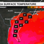
The storm is slowly moving to the NNE and is forecast to make a more northeastwardly turn as it approaches the Northern Gulf Coast of Louisiana Wednesday evening. Drier air has limited slowed the intensification of the storm. Although the warmer waters of the Gulf will help the storm to strengthen over the next 24-36 hours, rapid intensification is looking more unlikely with higher shear a limiting factor as well as the short time before landfall in the Gulf.
It will likely move inland over Louisiana as a Category 1 hurricane, before weakening rapidly after landfall as it moves inland over the Mississippi River Valley, before dissipating this weekend.
Significant storm surge up to 10 feet as well as hurricane force winds, and flooding rain will be the biggest hazards of Francine for the Gulf coast. Hurricane, Storm Surge and Tropical Storm Warnings are all in effect ahead of the storm from Texas to the Mississippi Coast.
Impacts:
Rainfall: 4-8 inches with up to 12 inches locally, leading to flash flooding
Wind: Hurricane Force Wind will begin in Louisiana by Wednesday
Storm Surge: Life threatening storm surge up to 10 feet will be possible for the Louisiana Coast
Surf: Dangerous surf and life threatening rip currents will be likely for much of the Gulf Coast
Carolinas Impact:
Although Francine’s track is well west of the Carolinas, there will still be some impacts felt for the region. Tropical moisture from Francine will spread well into the southeast leading to cooler temperatures and scattered to more numerous showers for the region Thursday evening through the start of the weekend.
PREVIOUS UPDATE 9/9
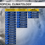
After an unusually quiet few weeks in the Atlantic basin, a disturbance in the Gulf of Mexico is forecast to organize and strengthen into a tropical storm Monday. Francine is the next name on that Atlantic Basin list. This would be the 6th named storm of the season. This is a bit behind the average at this point in the season. By September 9, there are normally 8 named storms, 3 hurricanes and 1 major hurricane that has developed in the basin. The peak of Atlantic Hurricane Season is September 10.

The disturbance is currently located more than 500 miles south of Cameron, LA. It is moving slowly to the north-northwest at about 5 mph. Sustained winds are at 50 mph, as the storm continues to organize. Although energy is building, there is still not a clearly defined center. However, conditions are favorable in the Gulf for further strengthening.
The storm is forecast to become Tropical Storm Francine later today off the coast of Mexico. It will strengthen quickly over the warmer waters of the Gulf and it will become a hurricane as it approaches the Louisiana coast mid-week.

Tropical storm watches are in effect for northeastern Mexico and parts of Southern Texas. The storm’s slow movement could bring several impacts to the Northern Gulf coast of Louisiana and Texas:
Storm Surge: Life-threatening storm surge for the Louisiana and Texas coastline
Rainfall: Parts of northeastern Mexico, southern Texas, Louisiana and Mississippi could see between 4-8 inches of rain, with some areas receiving up to 12 inches of rain. This could lead to flash flooding.
Damaging Wind: This is a growing concern for the immediate coastline
Dangerous Surf: Dangerous surf and life-threatening rip currents will impact the northern Gulf coast through the end of the week
As the storm moves inland, it will weaken quickly with the bulk of the impacts centered south and west of the area. However, the remnants of the storm could bring an increase in moisture across parts of the southeast, including the Carolinas. This means scattered showers and storms are possible. It is something to watch over the next few days.
Stay WeatherWise. Download the WCCB Weather App for the latest updates on the tropics.


