Tropical Storm Sara producing catastrophic flooding for Central America
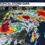
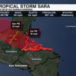

Tropical Storm Sara is forecast to make landfall in Belize over the weekend. Maximum sustained winds are at 50 mph as of Friday evening, but unfortunately for Central America, Sara is stationary.
Heavy rainfall will cause catastrophic flash flood and mudslides over northern Honduras through the weekend.
Sarah will weaken as it moves over southern Mexico. Moisture from this system is expected to merge with a cold front next week which will bring higher rain totals to parts of Florida.
PREVIOUS UPDATE: 10 AM 11/15
Tropical Storm Sara has brought devastating impacts to parts of Central America. As of Friday morning, the storm is located off the coast of Honduras and is slowly creeping westward at just 5 mph.

Flash flooding is ongoing for the region with rainfall totals of 25-35″ possible for the region through the weekend. This will lead to catastrophic flash flooding and mudslides as the storm basically stalls of the coast of Central America.
A mid-level ridge sitting northwest of the storm has acted as a guide, steering Sara toward Central America. However, the ridge is weakening which leaves Sara in neutral off the coast of Northern Honduras. Within the next day or two, as the ridge slides east, Sara will push northward toward Belize and move inland into the Yucatan Peninsula by the end of the weekend.
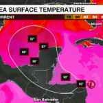
There is potential for the storm to intensify over the next day or so as it sits over the Caribbean, but once it moves inland over Belize it will likely weaken into a remntant low and merge with another system over the Gulf.
Heavy rainfall leading to flash flooding and mudlsides will remain the primary threat for Central America. Tropical storm force gusts and storm surge of 1-3 feet are also concerns.
PREVIOUS UPDATE 10PM 11/14
Tropical Storm Sara has formed in the Caribbean Sea.
Sara will bring potentially catastrophic flooding and mudslides to parts of northern Honduras before impacting Belize, El Salvador and parts of Mexico. Isolated locations in northern Honduras could see 30+ inches of rain.
Thanks to stronger steering currents, Sara is forecast to move over land this weekend. While land interaction is not good for those in Central America and Mexico, it is a good thing for the United States.
By the time Sara moves over the Yucatan and back into the Gulf of Mexico, the environmental conditions do not become conducive for a strong system to develop. It is still possible this system, or the moisture from this system, moves over Florida mid to late week next week. That being said, the odds of a hurricane are decreasing.
Those in Florida should pay close attention to forecast changes the next couple of days.
PREVIOUS UPDATE 10 AM 11/14
Tropical Depression Nineteen formed in the Caribbean Thursday morning. It will continue to organize and likely become Tropical Storm Sara by Thursday evening as it moves west toward Honduras. The storm will slow and stall near the coast over the weekend producing heavy rain that could lead to potential flash flooding and mudslides for eastern Honduras. It will begin to move northward this weekend, moving over Belize and the Yucatan Peninsula by early next week before crossing over into the Gulf of Mexico.

A Tropical Storm Warning is in effect for Honduras, while a Tropical Storm Watch is ineffect for Nicarauga.
Impacts and Hazards:
Rainfall: 10-20 inches with isolated totals up to 30 inches, producing life-threatening flash flooding and mudslides
Wind: Tropical storm force conditions will begin later today across Northern Honduras and the Bay Islands later today
Storm Surge: 1-3 feet of storm surge will be possible across the eastern coast of Central America
Once the storm moves into the Gulf of Mexico, the track and intensity of the storm becomes a bit more uncertain, but it will be something to watch over the next few days.
PREVIOUS UPDATE 10PM 11/13

MIAMI, FL — The National Hurricane Center (NHC) is watching Potential Tropical Cyclone Nineteen in the western Caribbean. The fledgling system will likely become Tropical Storm Sara over the next 48 hours as it approaches Central America.

Models have been pointing to future Sara slowly tracking northwest towards the Yucatán Peninsula this weekend before landfall by the start of next week. How strong the storm remains after landfall is key; medium-range guidance suggests future Sara will make a sharp easterly turn after it enters the Gulf. We’ll keep you weather-wise as the forecast becomes clearer.


