Snow and Arctic chill could impact weekend holiday plans
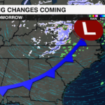
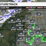
As we approach the final weekend before the holidays, the weather will turn frosty with wintry weather for the higher elevations and a cold blast that will linger through early next week. A fast-moving Alberta Clipper system will bring snow showers to the North Carolina mountains by the end of the week.

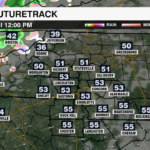
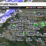
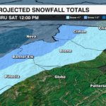
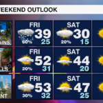
Timing: Snow showers will begin Friday afternoon, likely beginning as rain and changing to snow as colder air races into the mountains. The snow will intensify Friday night before tapering off by late Saturday morning.
Snow Totals: 1-3 inches of snowfall will be possible across the mountains, with up to 4-5 inches for the highest elevations above 5000′ near the Tennessee border. There could be a few flurries mixing into the rain outside of the mountains into the northern Piedmont, but no accumulation is expected.
Travel Impacts: Snow covered roads, gusty wind and reduced visibility could make travel hazardous in the mountains. If you’re traveling within or through the high country this weekend, consider leaving earlier in the day Friday, or waiting until later Saturday for conditions to improve.

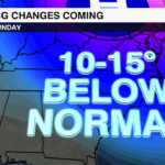
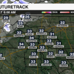
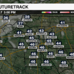
As the clipper system moves out, Arctic air will settle into the region. Temperatures will plummet Friday night with the coldest temperatures of the season ahead this weekend. Highs will only will struggle to reach the 30s in the mountains and mid 40s across the Piedmont. Wind chills will make it feel even colder, especially overnight into the early morning hours. Lows will fall into the teens and 20s areawide, but it will feel like the single digits if not below zero for the mountains. If you’re out shopping or running errands this weekend, bundle up and watch for icy spots in the morning, especially on elevated services like bridges and overpasses.
Looking Ahead to Christmas Week
It will remain chilly through Monday, but a gradual warming trend begins Christmas Eve with highs reaching the upper 40s. Temperatures will regulate by Christmas Day with highs back into the mid 50s — which is seasonable for this time of year.
A new system could bring some wet weather Christmas Day, so it will be something to monitor, but with temperatures above freezing icy conditions will not be likely.
Stay up with the latest forecast from the WeatherWise team even as you travel by downloading the WCCB Weather App.


