Bitter cold wind chills, black ice concerns through Friday morning
A fast moving upper level system brought scattered snow showers to the region this morning leading to light accumulations across the Piedmont. Bursts of heavy snow during the morning commute lead to an accident on I-85 NB in Rowan county that shut down two lanes of traffic for a few hours. The snow will taper off this evening in the mountains with an additional 1-2″ possible for the highest elevations near the Tennessee border. Wet roads and melting snow will refreeze overnight on untreated roads leading to black ice once again Friday morning.

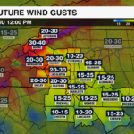
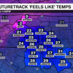
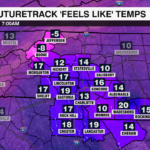
Gusty northwest winds will drive in bitter cold air Thursday. Highs will struggle to break out of the 30s, but with the wind it will feel like 20s through the afternoon. Overnight lows will tumble into the teens and 20s, but it will feel like the single digits and teens across the Piedmont, and 5-10 below zero for the mountains.

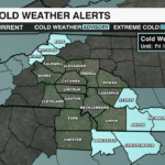
A cold weather advisory is in effect for Ashe, Anson, Avery, Chesterfield, Lancaster, Richmond, Stanly and Watauga counties through Friday morning. Prolonged exposure to the elements without proper attire could lead to hypothermia or frost bite. Make sure to keep pets inside as much as possible and check on older family members and neighbors.

The winds will die down Friday, but temperatures will remain 10-15 degrees below average with highs in the mid 40s Friday. Temperatures will slowly warm back into the 50s by this weekend.
Get the latest updates from the WeatherWise Team by downloading the WCCB Weather App.
Bitter cold temperatures and gusty northwest winds will
Greatest Impact:
- The greatest impact will still be on the roads Thursday morning. Black ice will form where there is moisture on the ground. Bridges and overpasses will freeze over first.
More Snow?
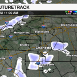
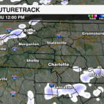
- A quick moving band of snow will move through between 7 am and noon on Thursday. This could add up to 0.5” of snow in spots, but it will not be widespread.

Snow Totals: This is as of 5 PM Wednesday
- Newland (Avery County) 2.0”
- Davidson (Mecklenburg) 0.8”
- Kannapolis (Cabarrus) 0.7”
- Troutman (Iredell) 0.5”
- Cherryville (Gaston) 0.5”
- Maiden (Catawba) 0.4”
- Charlotte (Mecklenburg) 0.2”
PREVIOUS UPDATE 2/19 11 AM.
Snow has been falling across the high country, foothills and Piedmont. The reason it didn’t start snowing sooner in Charlotte is because of drier air and limited moisture ate away at precipitation as it moved in, delaying the onset of snow in the Charlotte Metro and across the Piedmont.

Despite the delay, snow is still expected to develop this afternoon, especially for areas north and east of Charlotte. Moisture is streaming inland from a coastal low that will enhance snowfall rates leading to some higher totals east of I-85.

Regional Impacts:
There have been reports out of Avery County of 2″ of snowfall so far, with reports of a dusting up to .2″ for parts of the mountains and foothills into the I-40 corridor.
Mountains – On and off snow showers, 1-2″ in addition to what has already fallen
Foothills toward the I-40 corridor – Mainly Snow/Wintry Mix – 1/2 to 1″ accumulation
Piedmont – Wintry Mix – Up to 1/2″ of snow/sleet, up to 1″ north and east of I-85
NC/SC Border & South – Cold Rain/Wintry Mix early – little to no accumulation
Accumulations outside of the mountains will be light, but falling temperatures overnight will likely lead to any wet surfaces freezing over through Thursday morning. One last quick burst of snow will be possible Thursday morning from an upper level disturbance, but little to no additional accumulation is expected. Bitter cold temperatures with overnight wind chills in the single digits and teens will be possible through Friday morning, before warmer air arrives this weekend.
Get the latest updates by downloading the WCCB Weather App.
PREVIOUS UPDATE: 6PM 2/19CHARLOTTE, N.C. — A winter storm will move across the area Wednesday into Thursday morning. Limited moisture, plus a fast moving storm will result in limited impacts across the Charlotte area.
Timeline:
The snow will start in the mountains early Wednesday morning before moving into the piedmont by mid to late morning. It is possible the first pockets of moisture evaporate before reaching the ground. This will result in lower end snow totals.
Snow showers will be numerous Wednesday afternoon and isolated in the evening. Another quick moving burst of snow is possible Thursday morning.
Regional Totals:
- Mountains – All Snow – 2-4″ of snow, gusty winds
- Foothills toward the I-40 corridor – Mainly snow. 1-2″ of snow, light glaze of ice possible.
- Piedmont – Snow with a slight wintry mix – Up to 1″ of snow/sleet, light glaze of ice east of I-77.
- NC/SC Border & South – Cold Rain/Wintry Mix early – little to no accumulation.
Impact:
The greatest impact will be on the roads Wednesday evening into Thursday morning. Bridges and overpasses could be slick along with untreated roads.
2/18 UPDATE: 10 AM A fast moving winter storm will bring a mix of snow, sleet and ice to the region Wednesday. This will likely disrupt travel across the Carolinas with impacts beginning Wednesday morning near sunrise.

A Winter Weather Advisory will go into effect from 6 a.m. Wednesday until noon Thursday for much of the Piedmont and Foothills including: Alexander, Anson, Burke, Cabarrus, Caldwell, Cleveland, Catawba, Gaston, Iredell, Lincoln, Mecklenburg, Richmond, Rowan, Stanly and Union counties. A wintry mix is expected in the foothills and across the Piedmont with up to 2 inches of snow and sleet and a light glaze of ice possible.
A Winter Weather Advisory is also in effect from 1 a.m. Wednesday until 1 p.m. Thursday for Ashe, Avery and Watuaga counties. Higher snow totals are expected across the mountains with 2-4 inches of snow and wind gusts up to 35 mph.

Regional Impacts:
Mountains – All Snow – 2-4″ of snow, gusty winds
Foothills toward the I-40 corridor – Mainly Snow/Wintry Mix – 1-2″ of snow/sleet, light glaze of ice
Piedmont – Wintry Mix – Up to 1″ of snow/sleet, light glaze of ice east of I-77
NC/SC Border & South – Cold Rain/Wintry Mix early – little to no accumulation
The low pressure system will likely be near the Florida/Georgia coast Wednesday evening, before moving off the Carolina coast Thursday morning. This means as now, there are not any major shifts in forecast snow/ice amounts as the moisture stream remains focused over the eastern Carolinas and Virginia.

Travel impacts will begin with the Wednesday morning commute as snow and sleet may create slippery roads, especially north of I-85. Although surface temperatures will likely stay above freezing for the Piedmont, icing may occur on elevated surfaces like bridges and overpasses. The wintry weather will intensify by midday and taper off by Wednesday night outside of the mountains.

Overnight temperatures will quickly fall into the teens and 20s. This will likely lead to a flash freeze for any surfaces that remain wet. Black ice with one last burst of snow could lead to reduced visibility and slick morning travel. Bitter cold temperatures, but drier air will stick around through the end of the week.
Get the latest updates from the WeatherWise team by downloading the WCCB Weather App.
A winter storm will soon take shape to our west/southwest before impact the Carolinas Wednesday and Thursday. There are still uncertainties with this forecast like dry air and exactly how cold we get – both of these things could mean more or less snow.
Here is the latest as of Monday evening:
- Timing: Wednesday morning – evening with possibly another burst of snow Thursday morning.
- Precipitation Type: Mix of snow, sleet and freezing rain for Charlotte. Less ice and slightly more snow as you head north.
- Biggest Impact: Travel Wednesday through Thursday.
- Totals:
- CHARLOTTE:
- Snow/sleet: Trace-1”
- Ice: Coating – 0.10”
- SOUTH OF CHARLOTTE:
- Snow/sleet: 0 – < 1”
- Ice: 0.10-0.25”
- MOUNTAINS:
- Snow: 1-3”+
- FOOTHILLS:
- Snow: 1-2”
- Ice: Trace
- CHARLOTTE:
2/17 UPDATE: 11 AM — A fast moving winter storm will bring impacts to the Carolinas beginning Wednesday morning bringing a mix of snow, sleet, ice and a cold rain to the region. Models have been showing a slightly less intense low pressure system moving out of the Gulf with a track that is further east.

Here’s how models are trending as of Monday morning:
Less Snow Overall – The storm will not be able to tap into as much moisture, and is moving faster which means lower snowfall totals south of I-40
More Sleet & Freezing Rain – Warm air aloft is looking more pronounced which increases more sleet south of I-40 and more freezing rain east of I-77
Shorter Event – The weaker low will move faster away from the coast, meaning the snow and wintry mix will end Wednesday night outside of the mountains
If the colder air is able to settle further south, snowfall potential could increase. But, if it remains shallow, we’ll see more sleet and freezing rain. This will be a problem if the low tracks more slowly across the region as we could see higher ice totals. Expect this forecast to be fine tuned over the next 24 hours as a shift in track could change the forecast quite a bit.

Impacts by Region
Mountains – Snow Likely – 2-4″ for higher elevations
I-40 Corridor/Foothills – Snow/Sleet Mix – 1-2″
I-85 Corridor/Piedmont – Wintry Mix/Cold Rain – <1″, glaze of ice
South of I-85 – Mainly Cold Rain
The main impacts from the winter storm will begin to taper off Wednesday evening, but freezing temperatures overnight with highs only in the mid 30s Thursday could lead to black ice and hazardous travel.
Get the latest updates from the WeatherWise team by downloading the WCCB Weather App.