Warm & sunny start to weekend, more rain chances lurk ahead
Isolated showers on Sunday become more numerous into Monday.
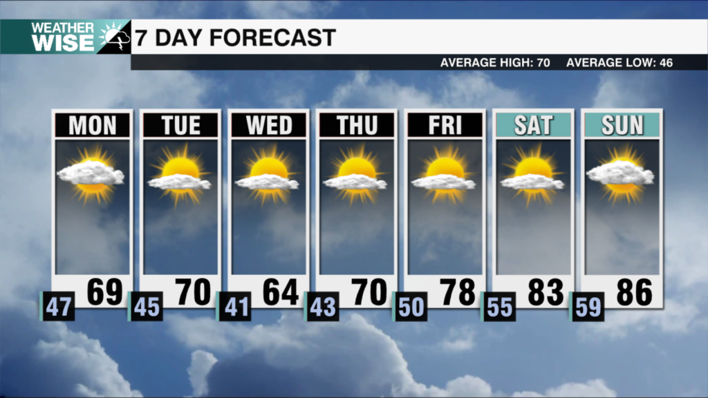
Clouds and cooler air have dominated March’s first Friday, but welcome changes arrive as we head into the weekend. Stiff southwesterly winds will keep lows in the upper 40s overnight as the clouds slowly clear out. Plentiful sunshine will fuel a warm-up well into the 70s across the Piedmont and Foothills on Saturday as a mostly dry cold front sweeps across the Carolinas. Northwesterly flow will lead to a few showers in the High Country throughout the first half of the weekend as highs struggle to crack 50º. Enjoy Saturday while it lasts – much cooler air filters in behind the front on Sunday. Highs will only rise into the 40s and 50s to close out the weekend as a moisture-laden system approaches from the southwest.
Isolated showers, mainly south and west of the Metro, will become more numerous as the rainmaking system draws closer overnight into Monday. The WCCB Charlotte viewing area will be on the northern edge of this storm; areas along I-40 and northward may remain mostly dry through the start of the workweek, while communities along I-85 have a better chance to see more meaningful rainfall. Regardless of what happens on Monday, sunny skies and warmer highs return by Tuesday, setting us up with what should be a wonderfully warm midweek.
Tonight: Clouds clear out. Breezy. Low: 48°. Wind: SW 5-15. Gusts: 20+
Saturday: Mostly sunny. Warm and windy. High: 74°. Wind: NW 10-20. Gusts: 25+
Saturday Night: Mostly clear early, then clouds build. Stray shower? Low: 40°. Wind: NE 5-10.
Sunday: Mostly cloudy with a stray shower. Much cooler. High: 58°. Wind: E 5-10.