Flood Watch in effect: repeated downpours could trigger flash flooding across the Carolinas
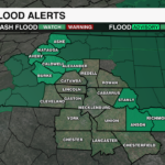
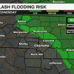

A slow moving system will bring rounds of heavy rain and storms to the southeast through the start of the week. A Flood Watch has been issued for Alexander, Anson, Ashe, Avery, Burke, Caldwell, Richmond, Stanly and Watauga counties through 2 p.m. Tuesday.

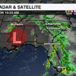
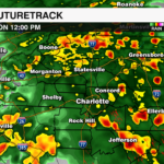
A cutoff low over the lower Mississippi Valley is pumping tropical moisture into the Southeast and Mid-Atlantic. The amount of moisture available over the area is 2 to 3 times higher than normal for this time of year, meaning the atmosphere is primed for heavy rainfall. There is also a lingering wedge of cool, stable air is trapped at the surface against the mountains locking in clouds and rain. This setup will enhance rainfall rates and lead to training heavy rain bands and storms that repeatedly hit the same areas.
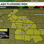
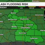
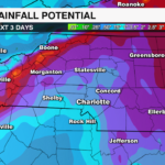
Rainfall totals could reach 3 to 5 inches, with isolated higher totals possible along southeast facing slopes of the high country. This increases the risk of flash flooding and landslides for the mountains and footills. Rainfall totals across the Piedmont will likely reach 1-3″, with locally higher totals of 2-4″ through Wednesday leading to urban flooding and ponding on roads.
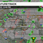
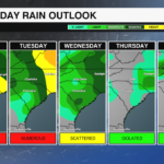
The heaviest rain will impact the area through Monday night, with scattered storms possible Tuesday afternoon through Wednesday as the low lifts north.
The PGA Championship at Quail Hollow announced Monday that spectators will not be allowed on the course. Tournament play will improve later in the week as high pressure fill in Thursday and Friday. However, humidity levels will remain high with temperatures soaring near 90 by Friday.
Stay up with the latest on the flooding threat with the WeatherWise team by downloading the WCCB Weather App.


