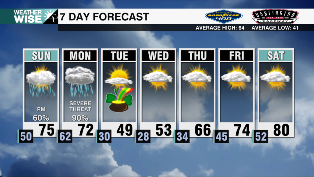
Storms will still be around for a while Monday afternoon as the cold front slowly moves away from the area. A few showers could linger on the backside of the system before things finally begin to clear out later in the day.
For Monday night, scattered showers continue into the early evening hours, mainly before 7 p.m. After that, skies will gradually start to clear. It will turn noticeably colder overnight with temperatures dropping to the 20s and 30s. Winds will also pick up out of the west-northwest between 10 and 20 mph, with occasional gusts reaching close to 30 mph. Any rainfall amounts will stay light, generally less than a tenth of an inch.
Behind the front, a much colder air mass settles in and you’ll definitely feel the difference. Tuesday morning starts off chilly with temperatures in the low 30s, and the wind will make it feel even colder. The breeze sticks around through the afternoon, making for a blustery day with highs only reaching the upper 40s to near 50 degrees.
The coldest part of the stretch arrives early Wednesday morning. Temperatures are expected to dip into the upper 20s, so if you have sensitive plants outside, you’ll want to make sure they’re covered. The good news is that sunshine helps temperatures recover a bit later in the day, with afternoon highs climbing back into the 50s.
Sunshine continues for the rest of the week and by Friday we are back in the 70s!
Click here for more local weather.