
Rain return Saturday night into next week
As we kick off the first weekend of the month, temperatures will start climbing back into the lower 90s on Saturday, and you'll definitely notice the humidity making a comeback.

As we kick off the first weekend of the month, temperatures will start climbing back into the lower 90s on Saturday, and you'll definitely notice the humidity making a comeback.
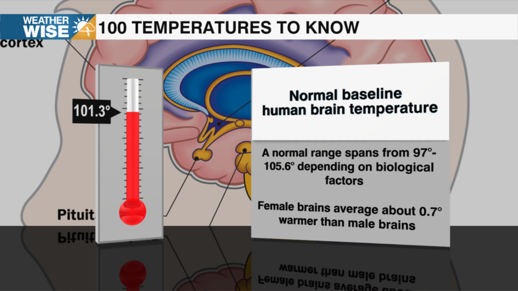
It's just a number, or is it? Every temperature has a story. Some mark important moments in nature, others reveal incredible science, and a few might surprise you. In "100 Temperatures to Know," we'll take one temperature at a time and uncover what makes it worth remembering.
Friday brings another warm summer day with a mix of sunshine and passing clouds. Afternoon temperatures will climb to around 90 degrees, while you'll notice the air becoming a little more humid, it still won't feel overly uncomfortable. The good news is that Friday stays completely dry, making it another great day for any outdoor plans before the weather becomes more active.

That refreshing pattern sticks around on Thursday with wall-to-wall sunshine and afternoon highs topping out around 87 degrees. Thanks to the lower humidity and a light breeze out of the north, it will feel much more comfortable than what we normally expect this time of year. Thursday night brings another cool and quiet night with lows once again settling into the mid-60s.
A Severe Thunderstorm Watch is in effect through 8 p.m. for the entire Charlotte metro and surrounding communities, including Mecklenburg, Cabarrus, Caldwell, Cleveland, Gaston, Iredell, Lincoln, Rowan, Stanly, and Union counties. The strongest storms could produce wind gusts as high as 70 mph, hail and torrential rain.

The region will squeeze in one more hot and humid summer day before a cold front finally pushes through. Afternoon highs will climb into the middle 90s, but with oppressive humidity, it'll feel more like 100 to 105 degrees. Storms are expected to begin developing during the afternoon before becoming more widespread through the evening hours. The greatest concern is between 3 p.m. and 10 p.m. Tuesday, when a few thunderstorms could become strong to severe.
Saturday follows a similar theme with comfortable temperatures, plenty of clouds, and another round of rain in the morning into early afternoon. It won't be an all-day washout, but keep the umbrella nearby if you have outdoor plans. Highs will remain in the 80s with some humidity creeping back up.

A cold front is expected to slide south of the region by Friday, bringing a noticeable drop in humidity along with much more comfortable temperatures. After days of tropical air, it's going to feel surprisingly refreshing. High temperatures from Friday through Saturday will run nearly 10 degrees below what's typical for late July. Instead of the usual muggy 90s, afternoon highs will stay in the 80s, making it one of the coolest stretches we've experienced in quite some time.
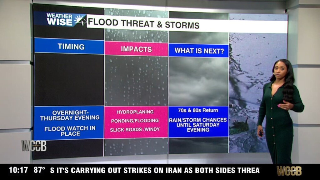
Rain continues through tonight with ongoing flood impacts
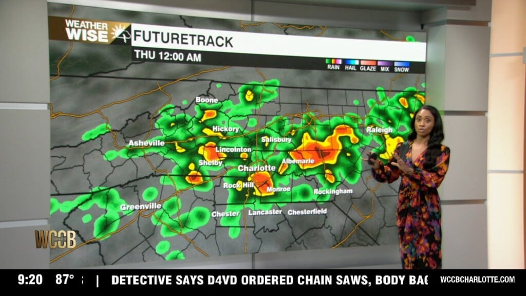
Tonight I'm watching a fading line of storms that may brush our northern communities, but most of the area should stay dry until Wednesday, when the atmosphere becomes much more active. Overnight lows will remain humid into the upper 70s
 Formerly Twitter


