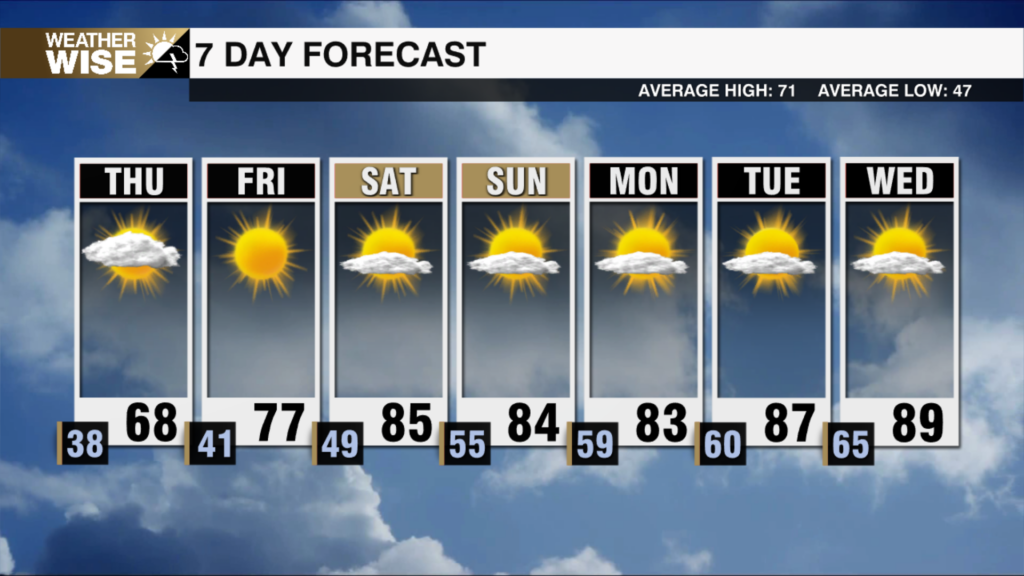
A Cold, and Blustery St. Patrick’s Day
Windy with bitter wind chills
If you’re stepping outside this morning, you’re going to notice a big change in the air.
Temperatures early Tuesday morning are sitting in the low 30s for many spots, and with a steady northwest breeze. Winds will continue to blow between about 10 and 20 mph through the day, with occasional gusts pushing close to 30 mph. So if you’re heading out early, you’ll want the winter coat again.
Even with sunshine returning today, it’s going to be tough to warm things up very much. Afternoon highs will only climb into the upper 40s to around 50 degrees across much of the region. That’s quite a drop compared to the mild weather we experienced recently, and a persistent breeze will keep it feeling cool all day long.
The coldest part of this stretch actually arrives tonight into early Wednesday morning. As winds relax a bit and skies stay mostly clear, temperatures will fall quickly overnight. Many areas are expected to dip into the upper 20s by daybreak Wednesday. That means a freeze is likely for a lot of locations, so if you’ve already started spring planting, you’ll definitely want to cover up any sensitive plants before heading to bed tonight.
The good news is that Wednesday afternoon looks a little more comfortable. Sunshine will help temperatures rebound into the 50s, giving us a bit of relief after the cold start.
Sunshine and warmer temperatures will persist into Thursday and Friday.