Tropical Depression Nine Forms In The Gulf, Soon To Be Isaias
Rain across the Carolinas expected this weekend
The Gulf is getting more active, and we now have our ninth named system of the Atlantic hurricane season.
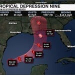
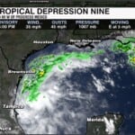
Tropical Depression Nine has formed over the southwestern Gulf of Mexico as thunderstorms around the area of low pressure became more organized.
Right now, the depression is moving slowly toward the east at around 5 mph. That general east to east-northeast track is expected to continue over the next couple of days, carrying the system toward the Yucatan Peninsula before it begins making a turn to the northeast.
What we are expecting
Conditions across the Gulf are expected to remain favorable for additional strengthening. This storm will turn into a Tropical Storm Isaias Wednesday and potentially reaching hurricane strength by Thursday.
By Friday, the storm is forecast to approach the northern Gulf Coast, with the current track pointing toward the Louisiana and Mississippi coastline.
The exact landfall location is still something we are watching. As the system moves farther north, it should eventually weaken after making landfall. The latest guidance keeps the center of the system west of the Carolinas.
The biggest concern for our region will be the moisture this system could help pull northward later this weekend. Even if the center stays well to our west, tropical moisture can still feed into a larger storm system and produce periods of heavy rain.
That could lead to some localized flooding and, depending on how much rain falls and how quickly it comes down.
As of now our highest impacts would be late Saturday and all day Sunday.
We’ll keep watching it and let you know what it means for our weather as we get closer to the weekend.