Isaias strengthens into the Atlantic’s first hurricane of 2026
Warnings are now in place across the Gulf Coast
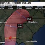
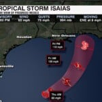
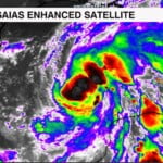
Hurricane Isaias continues to gain grow bigger in the Gulf and is expected to turn into our a Cat. 2 before landfall. Storm surge, strong winds, tornadoes and heavy rains that could lead to flash flooding all possible from Mississippi to northwest Florida.
A Storm Surge Watch is in effect for
* Mouth of the Mississippi River to Yankeetown
A Hurricane Watch is in effect for
* Bay St. Louis to Indian Pass
A Tropical Storm Watch is in effect for
* Jefferson/Plaquemines Parish line to west of Bay St. Louis
* East of Indian Pass to Aucilla River

By Friday, the storm is forecast to approach the northern Gulf Coast, with the current track pointing toward the Mississippi, Alabama coastline and the Panhandle of Florida.
The exact landfall location is still something we are watching. As the system moves farther north, it should eventually weaken after making landfall. The latest guidance keeps the center of the system west of the Carolinas.

The biggest concern for our region will be the moisture this system could help pull northward later this weekend. Thanks to the counterclockwise rotation around the low pressure (Isaias), rain will move into the Carolinas. That could lead to some localized flooding and, depending on how much rain falls and how quickly it comes down.
As of now our highest impacts would be late Saturday and all day Sunday, with rainfall ranging from 1-2″
We’ll keep watching it and let you know what it means for our weather as we get closer to the weekend.