Heating Up in the Tropics
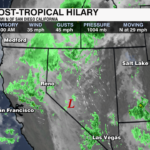
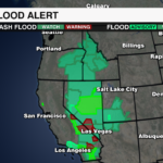

This weekend was active for the Eastern Pacific and Atlantic basins. There are now three tropical storms in the Atlantic. Two other areas have a high potential of becoming a tropical depression or storm over the next few days as well. Hilary is now post-tropical, but it brings a continued threat of flash flooding to the west.

Hilary at its strongest was a major category 4 hurricane. As it interacted with cooler waters and drier air off the Baja peninsula it weakened to a tropical storm before landfall Sunday. It is the first tropical storm in decades to hit California. It brought flooding rain causing landslides and flash flood emergencies across the state and into the southwest. As of Monday morning, the storm is now post-tropical as it lacks any center of circulation. The remnants of the storm still bring a flash flooding threat from California to as far north as Montana with up to 6″ of rain forecast to fall in some areas.

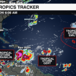
The Atlantic basin was also active this weekend. Three tropical storms formed including, Emily, Franklin, and Gert. The National Hurricane Center is monitoring two areas with a high chance of development over the next several days.
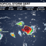
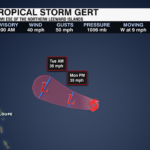
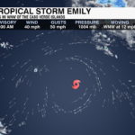
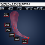
Tropical Storm Emily and Gert are located in the central Atlantic. Both are forecast to become remnant lows over the next 24 hours as they interact with drier air and higher shear areas. Neither poses a direct threat to land.

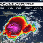
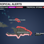
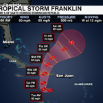
Tropical Storm Franklin will take a turn to the north in the next 36 hours eyeing Hispaniola. Up to a foot of rain is possible for parts of the Dominican Republic with up to 6 inches of rain possible for Puerto Rico. Tropical Storm Warnings are in effect for southern Haiti and the Dominican Republic. Tropical Storm Watches are in effect for the north side of the Dominican Republic and Turks and Caicos. Franklin is forecast to strengthen into a hurricane by the weekend as it moves over the open and warm waters of the Atlantic. It poses no threat to the mainland of the United States.

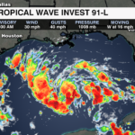
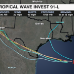
One of the two areas to watch for potential development include a disturbance in the Gulf of Mexico. Invest 91-L has a high chance of development within the next day or two as it nears the western coast of the Gulf. This storm would bring rain to the drought-stricken border of Texas and Mexico.
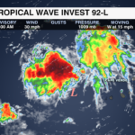
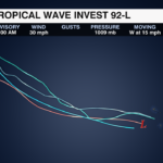
The other area to watch is located west of the Cape Verde Islands. It also has a high chance of becoming a tropical depression or storm over the next 5-7 days.

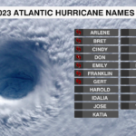
The next names on tap in the 2023 Atlantic Basin list are Harold and Idalia.
As we enter into peak hurricane season, remember it only takes one storm to cause major destruction. Make sure you are staying WeatherWise with the latest in the tropics. Download the WCCB Weather App for free today.


