Isolated Severe Threat Friday
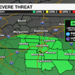
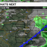
It has been more than a month since there has been a severe weather threat for the WCCB viewing area. However, that will change today. The Storm Prediction Center has highlighted a level 1 (out of 5) severe threat for areas south of I-40 this afternoon. Storms triggered by a cold front will be capable of producing damaging wind and up to quarter-sized hail.

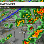
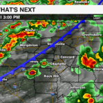
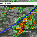
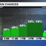
Light showers will move through the region Friday morning. A break in the rain through the early afternoon will allow instability to build. With plenty of moisture in place, storms will pop mid to late afternoon ahead of a strong cold front. This front will move through quickly, clearing the region by sunset tonight.

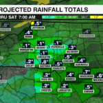
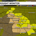
Drought is now impacting the entire region with abnormally dry to moderate drought from the Piedmont to the High Country. Rainfall totals could reach up to 1/2 to 1″ this afternoon. Any rain is beneficial. but it won’t be enough to end the drought as another stretch of dry weather begins Saturday.

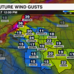
Behind the front, winds will pick up with gusts 20-30 mph across the Piedmont Saturday. Gusts across the mountains will be much stronger reaching 50+ mph. This could bring down a lot of the leaves across the high country, just as we have reached peak fall foliage. Winds will die down through the day on Sunday.
Cooler temps arrive Sunday night with lows falling into the 30s and 40s Monday morning.


