Tropical Storm Alberto Moves Inland Over Mexico
6/20 8AM UPDATE:
Tropical Storm Alberto brought heavy rain, strong wind and storm surge that caused coastal flooding for Southern Texas and Mexico. The storm will rapidly weaken and dissipate by Thursday evening as it moves further inland.
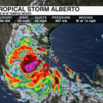
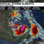
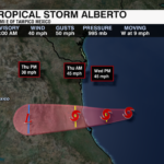
As of 8am Alberto is now 25 miles west of Tampico, Mexico. A drop in sustained winds and an increase in pressure indicate the storm is already weakening.
Impacts:
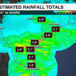
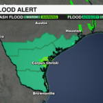
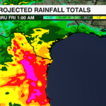
Rainfall: Less than 1″ for Southern Texas. 5-10″ rainfall totals still possible for NE Mexico, leading to flash flooding and mudslides.
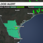
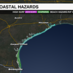
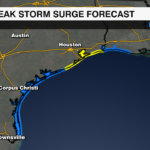
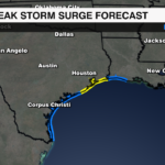
Storm Surge: Up to 2-4′ from Sargent, TX to Sabine Pass, TX and Galveston Bay
Tornadoes: Possible in Deep South Texas this morning.
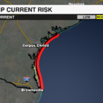
Surf: Dangerous surf and rip current risk along the Texas and NE Mexico coast through Friday
PREVIOUS UPDATE
6/19 11AM UPDATE:
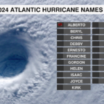
Tropical Storm Alberto has formed in the Western Gulf of Mexico. It is the first named storm of the 2024 Atlantic Hurricane Season and it is already bringing impacts to the Texas and NE Mexico coasts. It is expected to bring heavy rain, coastal flooding and gusty winds to the region through Thursday.

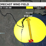
Alberto is currently located about 185 miles east of Tampico, Mexico and about 295 miles south-southeast of Brownsville, Texas. Tropical Storm Warnings are in effect from the Texas coast south through NE Mexico. Tropical Storm conditions are expected within the warning area today through early Thursday. TS Alberto is tracking west at 9mph and is expected to increase speed before making landfall along the NE Mexico coast early Thursday.

TS Alberto has maximum winds of 40 mph with higher gusts. It has a large wind field with tropical storm wind that extend out 415 miles from center. It will likely strengthen before making landfall. It will rapidly weaken after the center moves inland over Mexico and is likely to dissipate quickly late Thursday or early Friday.
Impacts

Rainfall: 5-10 inches likely. Up to 20 inches for the higher terrain of Mexico. This will likely lead to flash flooding and landslides.
Storm Surge: Up to 2-4′ from Sargent, TX to Sabine Pass, TX and Galveston Bay
Tornadoes: Possible in South Texas through this evening
Surf: Dangerous surf and rip currents along the Texas and NE Mexico coasts through Friday
Stay up to date with the latest on TS Alberto with the WeatherWise Team through the WCCB Weather App
PREVIOUS UPDATE
6/18 11AM UPDATE:

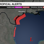
Tropical storm warnings are in effect for the Texas coast from Port O’Connor to the mouth of the Rio Grande, and for NE Mexico south of the Rio Grande to Puerto Altamira. Potential Tropical Cyclone One will likely become Tropical Storm Alberto within the next 24 hours. This will be the first named storm of the 2024 Atlantic Hurricane Season.

As of 11am, the disturbance is producing 40 mph sustained winds with a central minimum pressure of 999mb.
Potential Tropical Cyclone One is currently located 355 miles ESE of Pesca, Mexico and 410 miles SE of Brownsville, TX. It will move north and then gradually northwest over the warmer waters of the Gulf. This will provide energy needed for the storm to strengthen. Low wind shear and plenty of moisture will also contribute to its development before it moves over NE Mexico late Wednesday into early Thursday.

Tropical Storm conditions will begin tonight, or early Wednesday. Heavy rain and flooding is expected across parts of Texas and NE Mexico. Rainfall totals of 5-10 inches are likely with areas receiving up to 15 inches possible. Flash flooding is likely with landslides possible. Storm surge of 2-4 feet is possible for some Texas coastal areas. Dangerous surf and rip current risks are possible through Wednesday. Isolated tornadoes will also be possible for parts of South Texas Wednesday.

Get the latest updates on the tropics by downloading the WCCB Weather App.
PREVIOUS UPDATE
A broad area of low pressure has formed in the Bay of Campeche in the southwest Gulf of Mexico. This is forecast to become a depression or storm over the next few days as it heads toward the western Gulf Coast.

IMPACT: Heavy rain will likely bring flash flooding along with possible mudslides to parts of Central America into Northeast Mexico. Moderate coastal flooding is also possible along the Texas Coast.

ALERTS: Tropical Storm Watch is in effect from Port O’Conner southward to the mouth of the Rio Grande.

AREA #2: An area of low pressure may spin up on the tail end of a front off the southeast coast over the next couple of days. The development chance is low.

An area of high pressure will steer the low pressure to the southeast coast later this week.
IMPACT: Regardless of development, there will be an elevated rip current risk for the beaches with slightly elevated rain chances for coastal communities.