Hurricane Beryl Makes Landfall In Texas
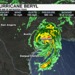
Beryl made landfall as a category 1 hurricane near Matagorda, TX early Monday morning. The storm continued to strengthen up until landfall, and has produced damaging wind, flooding rain and life threatening storm surge. At the time of landfall Beryl had sustained winds of 80 mph with a central pressure of 979 mb.

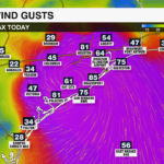
As of 8am, Beryl is located 40 miles SW of Houston. It remains a hurricane with sustained winds of 75 mph. Hurricane force winds have knocked out power to more than one million customers with gusts more than 80 mph.

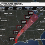
Life-threatening storm surge, damaging wind, and flooding rain will continue to batter southeast Texas Monday. Beryl will weaken the further inland it moves, likely becoming a tropical storm this evening into early Tuesday. It will continue to shift northeast toward the Mississippi Valley, becoming a remnant low by Tuesday evening, moving into the Ohio Valley by Wednesday evening.

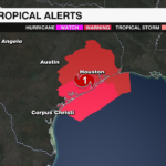
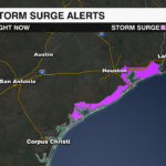
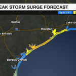
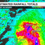
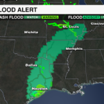
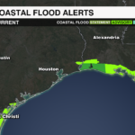
Hurricane and tropical storm warnings remain in effect for Southeast Texas with storm surge warnings in effect for the coast from Mesquite Bay to Sabine Pass. Storm surge of 3-7 feet will be possible for the coast. 5-10 inches of rainfall, with up to 15 inches possible locally causing flash, urban and river flooding. Tornadoes will be possible east of the center of Beryl for East Texas, Louisiana and Arkansas today. Life-threatening rip currents will stretch along the Gulf coast.
Get the latest updates on the tropics from the WCCB WeatherWise team by downloading the WCCB Weather App.
PREVIOUS UPDATE 8AM 7/3
Beryl remains a dangerous Category 4 Major Hurricane Wednesday morning. Hurricane conditions will begin in Jamaica by midday with life threatening winds and storm surge. It will approach the Cayman Islands by Thursday morning and the Yucatan Peninsula by Friday.

High shear and a drier environment is breaking down the structure of Beryl and weakening it slightly. However, this storm will remain extremely dangerous and a major hurricane as it moves over Jamaica. Further weakening is expected, but it will likely remain a hurricane as it approaches the Yucatan Peninsula Friday. The storm will move into the warm waters of the Gulf of Mexico as a tropical storm, but the environment will be more supportive for Beryl to reenergize into a hurricane Sunday. The final track of Beryl remains uncertain and impacts to the U.S. Gulf coast will still be possible and will need to be monitored through the weekend.

Hurricane Warnings are in effect for Jamaica and the Cayman Islands. Hurricane Watches are in effect for the east coast of the Yucatan Peninsula. A tropical storm watch is in effect for the coast of Belize.

Impacts:
Storm Surge: Jamaica – 6 to 9 feet, Cayman Islands – 2 to 4 feet, Yucatan Peninsula – 3 to 5 feet
Rainfall: Jamaica 4 to 8 inches, up to 12 inches in spots, Cayman Islands 2 to 4 inches, up to 6 inches in spots, Yucatan Peninsula 2-6 inches, up to 8 inches in spots with the threat of landslides
Surf: Dangerous and life threatening surf and rip current risks across the Caribbean.
Get the latest updates on the tropics from the WCCB WeatherWise team by downloading the WCCB Weather App.
PREVIOUS UPDATE 8AM 7/3
As of the 8am update from the National Hurricane Center, Beryl remains a dangerous Category 5 hurricane. Winds are sustained at 165 mph with gusts up to 200 mph. Central pressure has dropped to 934mb. The storm is moving to the west northwest at 22 mph.

Although some weakening is expected as it moves into a higher shear environment, it will likely remain a major hurricane as it moves near Jamaica Wednesday evening.
Hurricane warnings are in effect for Jamaica. The Cayman Islands are under hurricane watches. Tropical storm warnings are in effect for the south coast of Hispaniola. The storm will near the Cayman Islands by Thursday before moving toward the Yucatan Peninsula late this week.

Significant and deadly storm surge, destructive winds, flash flooding and life threatening rip currents and surf are the greatest threats.
Wind: Tropical Storm conditions for Hispaniola begin today, with hurricane conditions for Jamaica Wednesday.
Storm Surge: 4-6 feet above normal tide levels for Jamaica
Rainfall: 4-8 inches, localized up to 12 inches causing flash flooding
Surf: Large and destructive waves, along with life threatening surf and rip current conditions along the coasts of Jamaica, Hispaniola and the Cayman Islands
Get the latest updates on the tropics from the WCCB WeatherWise team by downloading the WCCB Weather App.
PREVIOUS UPDATE 11PM 7/1
You can read more on when Beryl first became a Category 5 hurricane here.
PREVIOUS UPDATE 11AM 7/1
Extremely dangerous Category 4 Hurricane Beryl made landfall on Carriacou Island with sustained winds of 150 mph. The Air Force Reserve Hurricane Hunters mission found the storm had strengthened with a central pressure down to 950 mb.
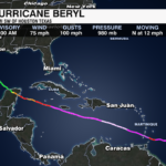
Beryl is expected to move west-northwest over the net few days. This track will continue to take the storm across the southern windward islands and it will move across the southeastern and central Caribbean through Wednesday where it will weaken to a category 2 hurricane as it interacts with the higher shear environment.
Impacts remain the same as the previous update with significant and deadly storm surge, catastrophic winds, heavy rain and dangerous surf the greatest threats.
Wind: Catastrophic wind damage expected in Grenada and the Grenadines and St. Vincent.
Storm Surge: Life threatening storm surge 6-9 feet with large and destructive waves near landfall
Rainfall: 3-6 inches of rain for Barbados and the Windward Islands with isolated areas receiving up to 10 inches, leading to potential flash flooding
Surf: Large, dangerous swells for the Windward and Southern Leeward Islands, extending to southern Puerto Rico and Hispaniola, creating life threating surf and rip currents
A hurricane warning remains in effect for Barbados, St. Vincent and the Grenadine Islands, Grenada and Tobago. A hurricane watch is now in effect for Jamaica. A tropical storm warning is in effect for Martinique, Trinidad and St. Lucia. A tropical storm watch is in effect for the southern coast of Haiti and the Dominican Republic.
Get the latest updates on the tropics from the WCCB WeatherWise team by downloading the WCCB Weather App.
PREVIOUS UPDATE 7/1 8AM
Hurricane Beryl has strengthened back into an extremely dangerous category 4, and will bring life-threatening wind and storm surge to the Windward Islands later this morning. Beryl underwent an eyewall replacement cycle overnight which dropped sustained winds slightly. However, the eyewall replacement cycle has resulted in a larger, and more defined eye wall which means the area of strongest winds has expanded.

It first intensified Sunday into a category 4 hurricane – the earliest on record. That record previously belonged to Hurricane Dennis when it became a category 4 hurricane on July 7, 2005.
Beryl will move over the Windward islands today, before moving into the southwest Caribbean by Wednesday. It is forecast to remain a hurricane through the end of the week. It will take aim a the Yucatan Peninsula by Friday, before moving into the Gulf of Mexico as a tropical storm this weekend.

A hurricane warning is in effect for Barbados, St Vincent and the Grenadine Islands, Grenada and Tobago. A tropical storm warning is in effect for Martinique, St. Lucia and Trinidad, while a tropical storm watch is in effect for Dominica, the south coast of the Dominican Republic and Haiti.

Wind: Catastrophic wind damage expected in Grenada and the Grenadines and St. Vincent.
Storm Surge: Life threatening storm surge 6-9 feet with large and destructive waves near landfall
Rainfall: 3-6 inches of rain for Barbados and the Windward Islands with isolated areas receiving up to 10 inches, leading to potential flash flooding
Surf: Large, dangerous swells for the Windward and Southern Leeward Islands, extending to southern Puerto Rico and Hispaniola, creating life threating surf and rip currents
Get the latest updates on the tropics from the WCCB WeatherWise team by downloading the WCCB Weather App.
PREVIOUS UPDATE 6/28
You can read more about Beryl becoming a tropical storm here.
PREVIOUS UPDATE 6/27
We could see our 2nd named storm of the 2024 Atlantic Basin Hurricane Season by this weekend. Invest 95L – a tropical wave located several hundred miles west of the Cape Verde Islands is producing disorganized showers and storms. It is moving west into an unusually conducive environment for further development in the Atlantic for late June. It has high potential to form into a tropical depression or tropical storm by this weekend.

Late June is usually a bit quieter for tropical development in the Central Atlantic. Sea surface temperatures are usually a bit cooler and shear is a bit higher. Optimally, ocean temperature needs to be above 80-85 degrees to fuel storm development. The deeper waters of the Eastern and Central Atlantic are usually much cooler at this time of year. The Saharan dust that travels over the Atlantic this time of year is very dry. It inhibits tropical development. However, due to the warmer waters of the Atlantic and an unusually moist atmosphere, the impacts of the Saharan dust are mitigated.

Another tropical wave in the western Caribbean is also being monitored by the National Hurricane Center. Some development is possible as it moves over the Southwestern Gulf of Mexico, but it has low chances of organizing into a tropical cyclone.
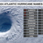
Invest 95L will approach the Windward Islands by late next week. The next name on the 2024 Atlantic Hurricane Name list is Beryl.
Get the latest updates on the tropics from the WCCB WeatherWise team by downloading the WCCB Weather App.


