Wind advisory in effect for the mountains: here’s what you need to know
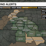
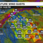
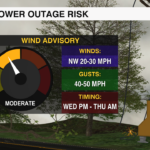
A Wind Advisory is in effect for Western North Carolina tonight as gusty northwest winds sweep in behind a strong cold front. Ashe, Avery and Watauga counties as well as the Caldwell and Burke Mountains are included in the advisory. A strong pressure gradient between an incoming high pressure system and a departing low pressure system to the north associated with the incoming cold front. Colder air will sink into the region behind the cold front, forcing the wind to accelerate. Gusty winds are strongest where terrain enhances the airflow. Gusts above 4,000 feet will likely reach 40-50 mph tonight with sustained winds of 15-30 mph.

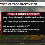
Strong winds could bring down trees damaged by Tropical Storm Helene. This could lead to scattered power outages across the mountains. Travel may be difficult for for high profile vehicles like trucks, vans and SUVs.

Secure loose items ahead of the strong wind so they don’t become projectiles. Charge your devices and keep flash lights handy in case of power outages. Use caution when traveling, and avoid traveling along mountain passes if possible.
The strong wind will gradually diminish after sunrise Thursday, but it will remain breezy into the start of the weekend.