Isolated severe storms possible on Thanksgiving Day
The severe weather risk is low Thursday, but not zero
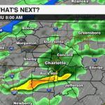
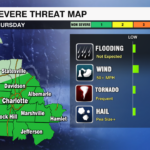
CHARLOTTE, N.C. — A powerful cold front will not only bring the coldest temperatures in over 300 days, but it will also bring the risk for severe storms on Thanksgiving Day.
Severe Threat:
- TIMING: Thanksgiving morning into early afternoon.
- IMPACT: Damaging wind and heavy rain are the primary threats. Isolated tornadoes and hail are also possible, but the threat is very low.
- RISK LEVEL: Marginal which is a level 1 out of 5 meaning isolated.

Cold Air:
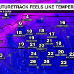
- TIMING: Cold air spills into the area early Friday, but the coldest air will arrive early next week.
- Friday: Low 39°. High 55°.
- Saturday: Low 28°. High 48°.
- Sunday: Low 29°. High 51°.
- Monday: Low 25°. High 47°. * Wind chills will near 0° in the mountains Monday morning. In the Piedmont, it will feel like the teens.
 The 5 Ps of Winter Preparedness:
PROTECT PEOPLE – Pay careful attention to children and the elderly. Dress in multiple layers when you are outdoors, especially at night when temperatures are below freezing.
PROTECT PETS – Bring your pets inside! If is too cold for you, it is too cold for them — especially with the cold, wet, and windy conditions. If your pet MUST absolutely be left outside, they should have shelter in a dry, warm place with their shelter facing AWAY from the wind.
PROTECT PLANTS – Cover them with blankets or bring them inside if you haven’t already.
PROTECT PIPES – Open cabinet doors to allow the warmth of your home to reach pipes under sinks and appliances near exterior walls. Open your faucets and allow a small stream of water to run at half the diameter of a pencil when temperatures drop into the 20s and teens.
PRACTICE FIRE SAFETY – Inspect all heating equipment before using. Check on your smoke and carbon monoxide detectors.
Stay safe and stay warm.