Hot start to summer’s final weekend
Slightly cooler air arrives in time for fall's first day on Monday, but highs likely remain at or above 85° in the Queen City over the next five days.
Happy Friday! We’re only three days away from fall, but summer isn’t going down without a fight. The Queen City will come awfully close to 90° this Friday afternoon; if we make it, it’ll be Charlotte’s first day in the 90s since August 18th – over a month ago. Expect more of the same on Saturday, although short-range models suggest we’ll be slightly cooler for summer’s penultimate day. A few stray-to-isolated showers and thunderstorms could find their way into the Piedmont this weekend, but most of the rain will remain west of the WCCB Charlotte viewing area. Temperatures cool slightly as we transition into fall between Sunday and Monday, but don’t expect afternoon highs to drop below the mid-80s over the next five days.
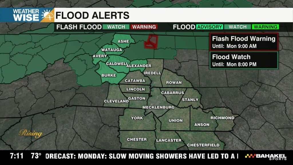
It’s been nearly two weeks since Charlotte last recorded a drop of rain. Significant rain chances remain at bay this weekend, but we could have a few opportunities for moisture next week as a cold front approaches from the west by Tuesday evening. Scattered showers and storms are possible between Tuesday and Thursday as the front pushes through and stalls just to our southeast. This could end up being the best of both worlds for us; the position of the front could bring in just enough cooler air for it to feel like fall again while keeping scattered rain chances around through much of the week ahead. With abnormally dry conditions sneaking into the WCCB Charlotte viewing area once again ahead of fall fire season, we could really use the rain – stay tuned!
Today: Sunny skies. Toasty highs. High: 90°. Wind: Light.
Tonight: Mostly clear. Milder. Low: 65°. Wind: Light.
Saturday: Another warm one. Stray PM storm? High: 88°. Wind: NE 5-10.
Saturday Night: A lovely evening. Low: 65°. Wind: NE 5-10.
Sunday: AM sunshine. PM partly cloudy.. High: 85°. Wind: NE 5-10.