Severe Storms Draw Near: Updated Impact Forecast
Stay WeatherWise this week and have multiple ways to receive warnings.
A severe weather outbreak looks likely across the south tonight through Thursday with the threat for strong to severe storms across the WCCB viewing area beginning Thursday afternoon.
Impacts:

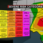
There is a threat of severe weather for the entire region. The Storm Prediction Center has highlighted areas south of I-40 as a Threat Level 3 out of 5 for severe storms Thursday. A line of thunderstorms will have the potential to bring damaging wind, quarter-sized hail, and even a few tornadoes. Discrete cells ahead of this mainline will be a big concern as temps soar into the mid-70s Thursday afternoon. That along with instability and shear gives these storms plenty of energy to feed off of to produce dangerous tornadoes.
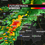
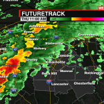
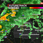
Synopsis
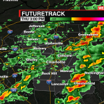
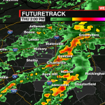
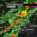
A strong cold front will sweep into the Carolinas by Thursday afternoon, bringing a broken squall line of storms with damaging winds, heavy rain, and sporadic hail along with it. While we’re not sold on the long-track tornado threat, we’ll need to watch carefully for quick, embedded spin-ups inside the main line and discrete supercells ahead of it.
Timing
Heavy showers may roll in overnight, but the main event won’t arrive until after sunrise Thursday. Right now, the timeframe for severe weather appears to be between 10 AM and 7 PM. The good news is that the arrival of the main line is trending earlier in the day, which will deny it of peak daytime heating. Less heat means less energy which, in turn, means less fuel for thunderstorms.
However, if it moves through a bit slower reaching the region during the later part of the afternoon, then there will likely be more widespread impacts from these severe storms. As of now, the biggest threat for severe weather will begin shortly before 12 pm and continue through early Thursday evening.
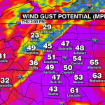
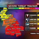
Impacts
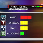
We’re most worried about damaging wind gusts, which could approach 60-70 mph along the squall line. Scattered-to-widespread power outages could be an issue as this line moves eastward. Localized flash flooding and hail up to golf-ball-size may also arise in areas that see the heaviest of the storms. While there isn’t a whole lot of fuel ahead of the main line, the potential is there for isolated supercell formation, especially south and east of Charlotte. That being said, we believe embedded, rain-wrapped spin-ups inside the main line will be the dominant tornado threat.
Bottomline
This dangerous system has a history of producing damaging wind and tornadoes. While we think the tornado threat will be lower here compared to our friends to our south, hurricane-force wind gusts could lead to widespread power outages and property damage across the area.
Make sure you have a plan in place and a way to get your weather information. It is important to have at least two ways to receive warnings. Download the WCCB Weather App. We’ll be live streaming to answer your questions and give you all the information you need, even if the power goes out.