Latest on Ida: Local Timing and Impacts for the Carolinas
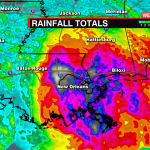

Hurricane Ida made landfall as a high-end category 4 major hurricane at 12:55 pm Sunday near Port Fourchon, LA. Ida caused major destruction across southeastern Louisiana with catastrophic storm surge, damaging wind gusts, and flash flooding. Radar estimates more than a foot of rain had fallen across parts of Louisiana. More than 1 million are without power this morning including the entire city of New Orleans after a transmitter fell into the Mississippi River.

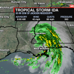
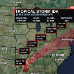
As of the 8am update from the National Hurricane Center, Ida is now a tropical storm with sustained winds of 45 mph and gusts up to 80 mph. It is moving slowly to the north and will begin to press north and east early Tuesday after moving into Tennessee.

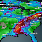
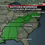
Flash flood watches are in place from Louisiana to New Jersey with Ida bringing the threat of more than 8 inches of rain across the south and into the east coast.

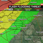
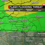
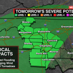
Locally, impacts from Ida will begin late Tuesday through Wednesday. There is a low-end severe threat with damaging wind and isolated tornadoes possible. The excessive rainfall outlook puts part of the mountains and foothills under a medium threat for localized flash flooding. Heavy downpours could produce intense rainfall rates, especially for the higher elevations. 1-2″ of rain is possible for the mountains with up to 1/2″ of rainfall for parts of the Piedmont. By Wednesday night Ida will move away from the Carolinas and drier cooler air will settle into the region.
Stay up to date with the latest information about Ida by downloading the WCCB Weather App Powered by Coit.