Track and Timeline of Today’s Severe Weather Threat
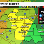
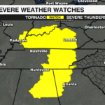

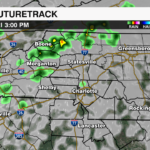
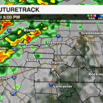
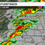
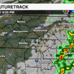
A line of strong to severe storms will move into the Carolinas today ahead of a cold front. The entire region has the threat of a severe storm today. A level 2 (out of 5) severe threat is highlighted by the storm prediction center for areas near and west of I-85. The largest widespread threat will be damaging straight-line winds. However, a tornado watch is in effect just to the west of the region. An isolated tornado cannot be ruled out. Localized flooding will be a concern for the mountains with 1-2″ of rainfall possible over a very short period of time.

The line of thunderstorms will be capable of producing damaging winds, isolated tornadoes and heavy rainfall. The storms will move quickly into the mountains between 3-5pm. The storms will arrive near the I-85 corridor between 5-8pm. It will clear the region by 8-10pm.

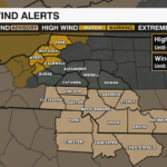
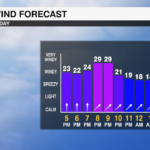
A high wind warning is in effect for the mountains until 10am Saturday with gusts 60+ mph and winds out of the west 20-30 mph with some of the strongest winds arriving after the front passes. A wind advisory is in effect for the Piedmont until 1am with winds out of the southwest 20-30 mph with gusts 40-50 mph.
Get the latest updates from the WCCB WeatherWise team by downloading the WCCB Weather App.