Severe Weather Preparedness Week: understanding severe thunderstorms and tornadoes
It’s Severe Weather Preparedness Week in the Carolinas, and today’s focus is on severe thunderstorms and tornadoes and the difference between watches and warnings. While thunderstorms are common in the Carolinas, they can quickly turn dangerous, producing damaging wind, hail and even tornadoes. Understanding the risks and knowing how to respond can make all the difference when severe weather strikes.
Severe Thunderstorms: More Than Just Rain and Thunder
A thunderstorm is a local storm that produces lightning and thunder. Thunderstorms can also produce rain, gusty wind and even hail. The Carolinas average 40-50 thunderstorm days a year, with about 10% of those classified as severe.
A thunderstorm is classifed as severe by producing at least one of the following:
- Hail at least 1″ in diameter, or the size of a quarter
- Winds of 58+ mph
- and/or a tornado
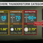
A Severe Thunderstorm is also categorized on its potential for damage:
- Base: Winds over 58+ mph, hail up to 1″ in diameter (quarter-sized)
- Considerable: Winds over 70 mph, hail up to 1.75″ in diameter (golf-ball sized)
- Destructive: Winds over 80 mph, hail up to 2.75″ in diameter (baseball-sized)
Note: Severe Thunderstorms categorized as ‘Destructive’ will also trigger a Wireless Emergency Alert (WEA) on mobile devices, just like Tornado and Flash Flood Warnings, or AMBER Alerts.
While all thunderstorms can be dangerous, severe thunderstorms in the ‘considerable’ or ‘destructive’ categories pose the greatest threat to life and property. Severe thunderstorm warnings should be taken as seriously as tornado warnings, and you should seek shelter immediately if it is issued.
The Power of Tornadoes
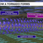
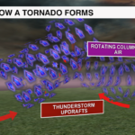
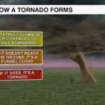
A tornado is a violent, rotating column of air extending from the base of a thunderstorm to the ground. Tornadoes need a few key ingredients to form:
- Shear: change in wind speed and direction with height
- Lift: the trigger for storm development
- Instability: rising air inside the storm
- Moisture: warm, humid air near the surface
Once a supercell forms and the rotating column of air is stretched and tightened by the storm’s updraft, a funnel cloud develops. If that funnel cloud touches the ground, it officially becomes a tornado. The stronger the wind shear and instability, the more intense the tornado can become.
Tornadoes can produce wind speeds more than 300 mph, and produce damage paths more than a mile wide. Tornadoes can stay on the ground for hundreds of miles, sometimes tracking across multiple states, and occur at any time of the day and any time of the year.
There has been a tornado recorded in every month of the year in the Carolinas. However, the most active months are March through June and again in the Fall during the peak of hurricane season. May tends to the be the most active month overall, with April producing the most deadly and destructive tornadoes in the Carolinas.
Watches vs. Warnings: What’s the Difference?
One of the most common weather questions is: What’s the difference between a ‘watch’ and a ‘warning’?
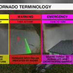
Watch = Be Prepared
A Severe Thunderstorm Watch or Tornado Watch means conditions could produce dangerous storms.
- Stay informed
- Review your emergency plan
- Make sure you have multiple ways to receive alerts
Warning = Take Action
A Severe Thunderstorm Warning or Tornado Warning means dangerous weather is happening now, or will happen soon.
- Seek shelter immediately
- Remain in your safe space until the storm has passed
Emergency = Take Action
A Tornado Emergency is issued when a large, violent tornado is confirmed on the ground and causing catastrophic damage.
- Life-threatening situation, only used in most extreme cases
- Take immediate action
- Do not leave your shelter until the all clear is given
Severe weather can strike at any time, and you may not always be near a TV when warnings are issued. Download the WCCB Weather App to receive weather alerts and updates during the storm so you can stay WeatherWise.