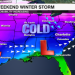
Weekend Winter Storm: Ice and sleet threat increasing
The clash of cold air and moisture will result in a significant winter storm for millions of Americans
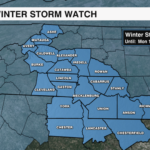
CHARLOTTE, NORTH CAROLINA (WCCB) — A Winter Storm Watch is in effect from Saturday morning through Monday afternoon across portions of the piedmont, foothills and mountains. 
A major winter storm that is impacting nearly 20 states across the deep south to the east coast will be crippling for millions.
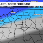
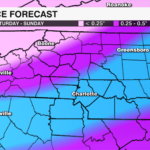
FIRST CALL ON TOTALS:
- NC Piedmont:
- Ice: 0.50+” (0.75” not off the table)
- Sleet: 1-2”
- Foothills:
- Ice: 0.25-0.50”
- Snow & Sleet: 2-4”
- Mountains:
- Ice: < 0.25”
- Snow & Sleet: 3-6”
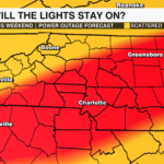
 IMPACTS:
- Widespread hazardous road conditions
- Power outages likely
 TIMING:
- Late afternoon – early evening Saturday through Sunday.
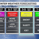
QUESTION MARKS:
- How much will fall as freezing rain and how much will fall as sleet? This depends on the temperatures well above our heads.
- It is POSSIBLE dry air cuts down on totals on Sunday. This is a best case scenario right now and not a slam dunk, but is something we are watching.
COLD TEMPERATURES:
- This is a big problem if we have prolonged power outages and snow or ice on the ground. It could take days and days to melt. I am still forecasting single digit low temperatures early next week
 Better to prepare now:
- Have enough food, water and medicine to last several days
- Get flashlights and batteries
- Put gas in your car – gas stations may lose power
- Have an extra heat source – get a generator if you’re able. Get firewood. Have plenty of blankets.
- Check your carbon monoxide and snow detectors (snow and/or ice accumulation can block vents so you want to make sure these are working)