Strong Winds & Rain Overnight With Gradual Clearing Friday
Gradual clearing on Friday with a nice and sunny weekend ahead
Weather Headlines:
– Weakening line of storms moves in late this evening.
– The severe weather risk is very low, but winds will be strong regardless.
– Secure anything you can outside – umbrellas, plants, basketball hoops etc.
– Gradually clearing on Friday with a nice weekend ahead.
WIND ADVISORY across the entire area. In effect until 5 am for the Mountains and until 7 am for the Piedmont.
We are under a Marginal Risk (level 1 out of 5) tonight. Isolated storms may be capable of producing straight-line winds.
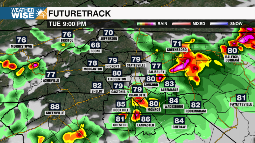
After a spring-like day, a cold front is heading toward the Carolinas. The wind and rain will crank up from west to east this evening. The mountains could start seeing extremely strong winds and heavy rain around 10 pm. The line will weaken as it moves across the area with the heaviest rain and strongest winds for the metro around 2 am. The heavy rain will be brief and will not amount to much.
– TIMING: 10 PM – 4 AM
– PRIMARY THREAT: Damaging winds
– POSSIBLE WIND GUSTS: The wind will be very strong aloft around 5,000 feet, therefore, the higher elevations in the mountains could see gusts up to 60 mph. Isolated winds may gust up to 45 mph across the Piedmont.
Expect gradual clearing on Friday with highs in the mid 60s. Dry conditions dominate the weekend with highs in the upper 50s, near 60. Next week looks unsettled with temperatures above average.
Tonight: Cloudy, windy, warm and wet. Rain and isolated storms from 10 pm – 4 am from west to east. Low: 55. Wind: S 15-20 G. 30-45.
Friday: Early AM showers with isolated storms possible. Gradual AM clearing. High: 65. Wind: W/NW 5-15.
Saturday: Sunny. High: 60. Wind: W/NW 5-15.
Secure loose objects outside!
Kaitlin