Windy Day Ahead of Possible Severe Storms Late Afternoon

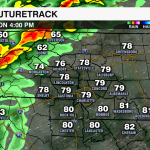
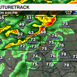


A strong cold front will bring the threat of severe weather this afternoon to parts of the region between 4 pm and 9 pm this evening. Damaging wind gusts will be the greatest threat, but an isolated tornado cannot be ruled out.

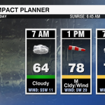
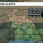
Ahead of the front the wind will be picking up. A wind advisory is in effect from 10am until 7pm for areas north of I-85. This is where gusts could exceed 40mph today. Winds will be out of the southwest 10-20 mph with gusts 30-40 mph for areas south of I-85.

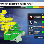
The Storm Prediction Center has put areas north of I-85 under a level 2 threat of severe weather today. This indicated the possibility of scattered severe storms. Damaging wind will be the greatest threat, but can’t completely rule out an isolated tornado. The one thing lacking in the forecast will be instability as this front moves over the Appalachians. This likely means the line will fall apart and the severe threat will weaken.

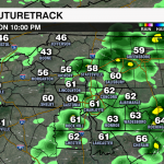
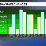
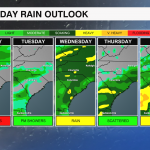
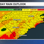
This front will settle south of the area overnight with showers tapering off after midnight. However, it will lift late Tuesday keeping the forecast unsettled with showers and even on and off heavy downpours in the forecast through Saturday. This could bring a localized flooding threat to the region by the end of the week with 1-3″ of rainfall to the area.