Summertime Pattern Continues, Watching Severe Threat Sunday
Sunday's storm system should bring some relief from the heat and humidity, but it won't last long.
Mother Nature is putting the “fry” into our first Friday of July. Highs have peaked above 90º for the eighth straight day, but bubbling afternoon thunderstorms will do what they can to cool us down. Expect more of the same for our Saturday, as temperatures top out in the 80s for the High Country. Lows will remain mild and muggy in the 60s and 70s with stray pop-up storms mainly before midnight. A welcome, albeit slight, drop in heat and humidity arrives by the start of next week, but we’ll have to go through a nasty Sunday to get it.
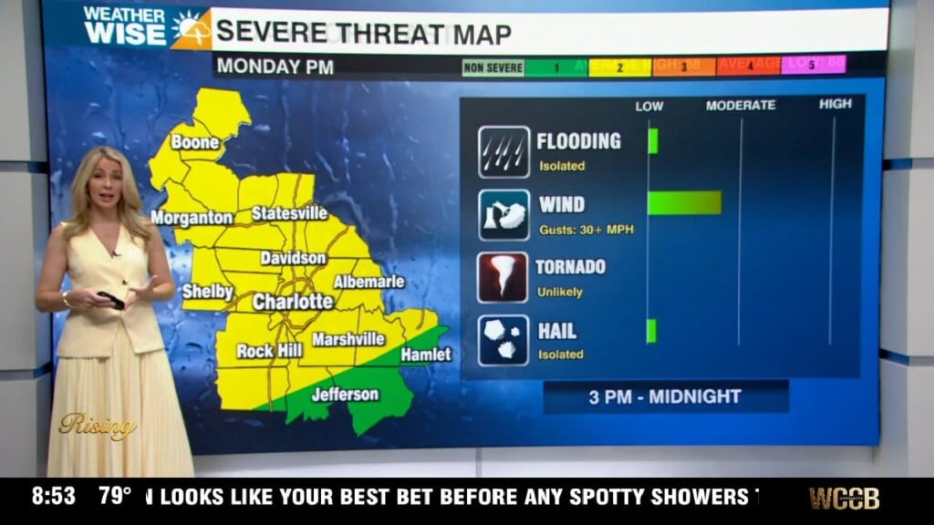
A powerful cold front pushes in from the northwest by Monday afternoon, bumping up storm chances into the scattered-to-widespread range for the second half of the weekend. While the severe threat doesn’t look particularly high at the moment, the strongest cells could pack hail, gusty winds, and localized torrential rainfall. A quick spin-up tornado or two isn’t completely out of the equation yet, either. Highs will drop into the 70s and 80s on Tuesday, but the heat and humidity come roaring back by the end of next week.
Tonight: A few storms early, then partly cloudy. Low: 73°. Wind: Light.
Saturday: Mostly sunny with a few PM storms. High: 93°. Wind: NW to SW 5-10.
Saturday Night: Another mild and muggy night. Low: 73°. Wind: SW 5-10.
Sunday: Partly clouds with PM scattered storms. A few may be severe. High: 93°. Wind: SW 5-15.