Brief Relief After Severe Threat Sunday
Summer comes roaring back again by midweek.
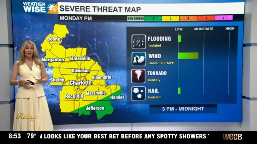
Heavy downpours did their best to end the streak, but Charlotte has topped out in the 90s for the ninth-straight day this Saturday afternoon. The 90s should stretch into the second half of the weekend, but an incoming frontal system will stop them cold by the start of the workweek. Cooler and drier air will be something to look forward to. The storms along the front? Not so much. A Level 2 (out of 5) severe risk has been issued for areas along and east of I-77 for Sunday afternoon and evening. While they should be isolated in nature, the strongest cells will pack damaging winds and torrential rainfall. Fortunately, the hail and tornado threat is minimal.
It won’t be perfect, but noticeably more comfortable air pours into the Carolinas on Monday and Tuesday. Scattered showers may impact your Monday morning commute, but highs will sit in the 70s and 80s for most with mostly sunny skies in the afternoon. Enjoy the brief reprieve from the heat while it lasts, because summer comes roaring back shortly after. The hot, humid, and stormy pattern picks up where it leaves off this weekend as highs return to the mid-to-upper 90s through the second half of next week.
Tonight: Mild and muggy. Low: 73°. Wind: Light.
Sunday: PM scattered storms. A few may be severe. High: 91°. Wind: W 5-10.
Sunday Night: A few storms early, then some clearing. Low: 70°. Wind: NW 5-10.
Monday: Scattered AM showers, then sunny and dry. High: 84°. Wind: N 5-10.