Strong to Severe Storms Ahead of Cold Front Overnight into Early Wednesday
AM Headlines:
- WeatherWise Alert Overnight into Wed AM
- Strong to Severe Storms Possible
- 3am – 9am
- Threats: Damaging Wind (main concern), Quarter+ Sized Hail, Isolated Tornadoes
- Much Colder, Windy Wednesday PM
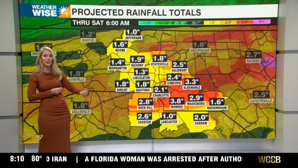
- Snow for the mountains = Up to 1″ above 3500′
- Below Average, but staying dry through the weekend
Discussion:
Temps will warm well above average today with highs reaching the low 80s. Breezy this afternoon with winds gusting up to 30 mph. It will likely feel even a pinch muggy as humidity rises across the region. A cold front will track through the region overnight into early Wednesday. Ahead of this front scattered thunderstorms will develop. A few of these may be on the strong to even severe side. Although timing should be in our favor, straight line wind damage and isolated tornadoes remain a concern for any storms that hold their strength after sunset to our west. Storms will move in between 3am until 9am with the severe threat ending after the passage of the front Wednesday morning. Prepare for a steep drop in temperatures Wednesday PM with winds increasing through the day. Snow may be possible for the mountains with accumualtions up to an inch for areas above 3500′. It will be a cold start Thursday with temps in the 20s and 30s for much of the region. Highs will struggle to break out of the low 60s. Below average temps will linger through the weekend with highs rebounding by Monday into the lower 70s.