Prepare For A Wet and Windy Thursday
Isolated severe storms possible Thursday afternoon
Forecast:
Tonight: Mostly cloudy. Patchy fog. Showers increasing early Thursday morning from west to east. Lows: Low 60s.
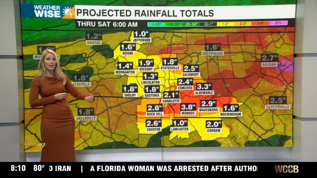
WeatherWise Alert Thursday: Widespread rain and general thunderstorms overnight into the afternoon. Rain could be very heavy at times. It is possible for isolated severe storms to develop, but the greatest threat is to our south and to our north. IF we see sun by midday, we could get isolated cells to develop in the afternoon. It will be very windy even outside of storms. Wind: SW 15-25 with gusts up to 40 mph. Highs: Mid 70s.
Severe Weather Risk:
We have a low risk (level 1 of 5) in place for Thursday
THREATS: Heavy rain and isolated damaging wind gusts are our primary threats. Isolated tornadoes and hail are possible if anything develops late afternoon, but the threat is very low.
TIMING: Overnight through the afternoon. With isolated strong thunderstorms possible in the afternoon – early evening.
Friday: Breezy, sunny and dry. Highs: Upper 60s.
Weekend: Dry and beautiful! Mid 70s on Saturday and low 80s on Sunday.