High wind warning issued for the High Country

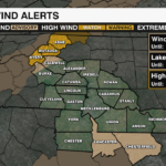
A powerful Arctic cold front will begin to sweep into the region tonight, bringing damaging wind and another blast of bitter cold temperatures. Gusts up to 60 mph will be possible for the high country. This could lead to downed trees, dangerous travel and power outages. A High Wind Warning will go into effect Wednesday night through Thursday afternoon.

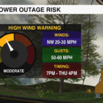
High Wind Warning
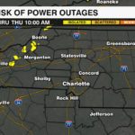
Where: Avery, Ashe and Watauga Counties
Timing: Wednesday 7 p.m. – 4 p.m. Thursday
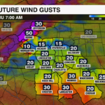
Winds: Sustained NW 20-30 mph, gusts up to 60 mph
Impacts:
-
-
- Strong wind could knock down trees and power lines, leading to scattered to widespread power outages
- Hazardous travel, especially for high profile vehicles
-
Wind Advisory
Where: Burke and Caldwell Mountains
Timing: Wednesday 7 p.m. – 4 p.m. Thursday
Winds: Sustained NW 15-25 mph, gusts up to 50 mph
Impacts:
-
-
- Tree limbs could be blown down causing power outages
- Driving may become difficult, especially for high profile vehicles
-

The Big Picture and How to Prepare
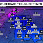
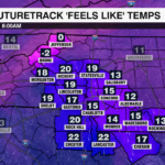
The strongest wind will develop overnight and persist into Thursday afternoon. These gusts along with a rush of Arctic air, will send temperatures plummeting into the teens by early Thursday night in the mountains with near zero wind chills. Snow will also be possible Wednesday night into early Thursday for parts of the High Country near the Tennessee border. Snowfall totals from a dusting to up to 2 inches will be possible for the highest elevations. This could make travel slick Thursday morning.
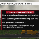
Safety Tips:
-
- Charge your devices: Be ready for potential power outages
- Secure outdoor items: Strong winds can turn loose items into projectiles
- Limit travel: Mountain roads will be especially dangerous during peak winds
Download the WCCB Weather app for the latest alerts and updates from the WeatherWise team.


