Winter Weather Advisory issued for the North Carolina Mountains
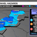
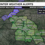
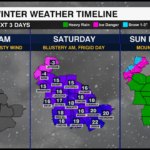
A Winter Weather Advisory has been issued for parts of the North Carolina Mountains including Ashe, Avery and Watauga Counties through 4 a.m. Saturday, January 4. Snow and gusty winds will impact the region beginning midday Friday with plummeting temperatures by late Friday afternoon. Travel could become hazardous from slick roads and reduced visibility.

HAZARDS
- Snowfall: 1-3 inches will be possible, with higher totals above 5000′ and for westward facing slopes near the Tennessee border. The heaviest snow is expected through Friday evening.
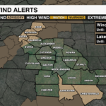
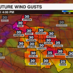
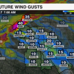
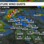
- Winds: Gusts up to 50 mph will create blowing snow, reducing visibility and making travel dangerous. Strong gusts could also bring down trees and cause isolated power outages
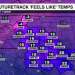
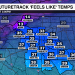
- Temperatures: Temperatures will plummet into the teens and 20s overnight, with wind chills falling below zero. Highs will struggle get above freezing Saturday afternoon.


IMPACTS
- Snow covered roads will make travel dangerous, especially in higher elevations
- Power outages are also a concern as gusty winds could bring down trees and power lines
- Blowing snow will reduce visibility causing potential white out conditions for drivers
If at all possible, avoid travel through Saturday morning. If you must travel, take it slow and allow extra time. Prepare for power outages by charging devices and having non-perishable food on hand. Wind chills below zero are dangerous for animals. Remember to bring your pets inside and dress for the cold to avoid frost bite with any prolonged exposure.

The snow will taper off overnight with gusty winds quieting by Saturday evening. This is just the first of two systems that will impact the region this weekend. A low pressure system will bring a wintry mix of snow and freezing rain. Make sure you are prepared and stay WeatherWise. Download the WCCB Weather App to stay up to date with the latest forecast.


