WeatherWise Alert: wind advisory in effect Thursday night for the high country
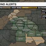
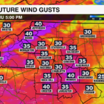
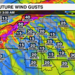
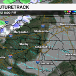
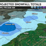
A Wind Advisory is in effect for the North Carolina mountains tonight from 8 p.m. until 8 a.m. Friday for Ashe, Avery and Watauga counties, as well as the Burke and Caldwell Mountains. Behind a cold front moving through the Carolinas Thursday morning, a strong pressure gradient will set up over the region, pulling in colder air from the northwest. As this air funnels through mountain gaps and ridges, wind speeds intensify — especially after sunset when stronger winds aloft mix down to the surface. The strong northwest flow and colder temperatures will also lead to 1-3″ of snow for elevations above 3500′.
WHAT TO EXPECT:
- Sustained Winds: NW 20-30 mph
- Gusts: 50-60 mph
IMPACTS:
- Downed tree limbs and scattered power outages
- Difficult driving conditions for high profile vehicles
- Blowing snow at higher elevations, reducing visibility
Stay with the WCCB WeatherWise team for updates, and check the WCCB Weather App for the latest wind gusts and forecast impacts.