Wedge erodes, warming up
AM Headlines
- Clouds clear, warming up
- Muggy Thursday
- Strong to severe storms Friday
- Pleasant Weekend
Discussion
Wedge Breaks, Clouds Clear & Much Warmer
We’re finally starting to break out of the dreary, damp wedge pattern today. After days of cool temperatures and drizzle, sunshine returns across much of the area this afternoon, especially south and east of the mountains. Expect highs in the mid to upper 70s with a chance for a few isolated showers or a stray mountain thunderstorm late in the day. Thursday will feel more like summer – warm and muggy with highs in the low to mid 80s. The morning and early afternoon should stay mainly dry, but scattered showers and a rumble of thunder late in the day as moisture builds ahead of an approaching cold front.
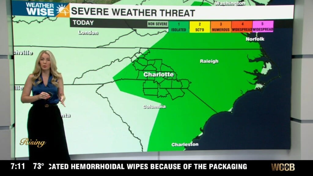
Friday Severe Threat
Friday is our biggest weather day of the week. A cold front will move through during the afternoon and evening, triggering widespread showers and thunderstorms. Some storms could be strong to severe, especially watching an area south and east of I-85.. The Storm Prediction Center has placed this area under a Slight risk, or Level 2 (out of 5) severe threat for damaging winds and isolated hail. Storms will clear by the early evening as the front moves east of the region toward the coast.
Pleasant Weekend, Getting Hot Next Week
Behind the front, skies will clear, humidity drops, and we’re looking at a pleasant start to the weekend with highs in the upper 70s to low 80s. A stray shower can’t be ruled out in the mountains, but most areas will be dry and comfortable. Sunday looks slightly more unsettled with a chance for showers across the mountains, but the rest of the area will stay dry with highs in the low 80s. High pressure builds in and sets up a warming trend under mostly sunny skies next week. Expect temps in the low to mid 80s Monday and Tuesday, with only a slim chance for a pop-up afternoon shower.
Behind the front, skies will clear, humidity drops, and we’re looking at a pleasant start to the weekend with highs in the upper 70s to low 80s. A stray shower can’t be ruled out in the mountains, but most areas will be dry and comfortable. Sunday looks slightly more unsettled with a chance for showers across the mountains, but the rest of the area will stay dry with highs in the low 80s. High pressure builds in and sets up a warming trend under mostly sunny skies next week. Expect temps in the low to mid 80s Monday and Tuesday, with only a slim chance for a pop-up afternoon shower.