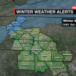
Potential Wintry Mix Late Saturday for Charlotte
The models are coming together with a little more to bring a disturbance to the region late Saturday into Sunday morning.
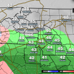
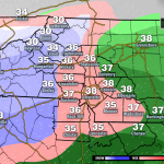
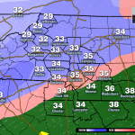
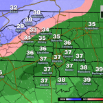
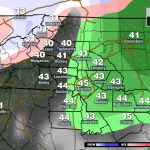
This setup could bring a wintry mix as far south as the I-85 corridor. With a mix of sleet and snow for locations north of I-40. Showers will begin after 4 pm Saturday. The upper layers will be cold enough to support some wet flakes and sleet by 7 or 8 pm for areas across the Piedmont. The question will be how quickly temps at the surface cool and how snowfall rates will get to support any accumulation.
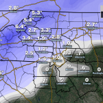
Accumulations do not look likely far south of I-85, but we could see a quick 1″ of snow/sleet before warmer air nudges for areas north of I-85 and up to 2″ of snow closer to I-40.
For the foothills 2-4″ of snow will be possible the higher in elevation. While the mountains are now under a Winter Storm Watch. This is where 3-6″ of snow with a coating of ice will be possible. Dangerous driving conditions and power outages could cause issues early Sunday. Any precip will wrap up by Sunday morning.