WCCB Weather

Latest Forecast

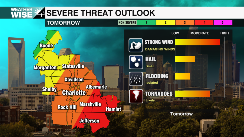
Cooler temperatures with increasing clouds Tuesday

Tuesday brings a big cooldown that you’ll feel right away. We’ll start the morning with lows near 40s with cooler air filtering in from the north will keep temperatures from recovering much. Afternoon highs will struggle to reach 60 degrees for most areas. That’s a drop of nearly 30 degrees, so it’s going to feel like a shock to the system. Wednesday starts the turnΒ around. Sunshine returns, and temperatures begin to climb a bit, getting us closer to more seasonable levels. It won’t be a huge warm-up, but you’ll notice the difference compared to Tuesday.

WCCB Weather Radar

Track storms live.

Current Conditions

Hourly Forecast

Extended Forecast

Significant severe weather threat tonight through Monday

The severe weather threat is continuing to build across our region late tonight into Monday. The primary threats are damaging winds and even a few tornadoes, especially for locations south of I-85 and along and east of the I-77 corridor.

Severe Weather Preparedness Week: Flooding

We say it all the time: turn around, don’t drown. That’s for good reason - the #1 cause of avoidable death from severe weather in the Carolinas is drivers trying to make it through flooded roadways.

Severe Weather Preparedness week: Lightning safety

There is a 1 and 15,300 chance you could be struck by lightning in your lifetime. Meteorologist Kaitlin Wright says, in order to avoid being a part of this statistic, do not wait until the last minute to get into your safe place.

Day 1 of Severe Weather Preparedness Week: Severe Thunderstorms and Tornadoes

Did you know that about 10% of thunderstorms in the U.S. each year are classified as severe? That means they can pack wind gusts of 58 mph or higher, produce hail the size of a golf ball or bigger, or even spawn tornadoes. These storms are serious threats to both life and property, so it’s crucial to be ready.

WCCB Weather Team

Contests

𝕏

X Wccbcharlotte Follow 370x70 Formerly Twitter