Today’s Weather Forecast
[gtxvideo vid=”TNyp4sL0″ playlist=”” pid=”XkGI5ukr” thumb=”http://player.gtxcel.com/thumbs/TNyp4sL0-120.jpg?cachebust=1508711546149″ vtitle=”WCCB Weather 6pm October 22, 2017 Michelle”]
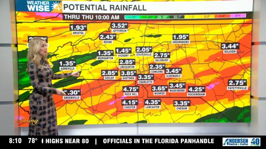
High pressure will continue to break down and shift east, ahead of our next weather maker. A low pressure system along with a cold front will sweep across the area Monday through Monday night. The Mountains will see 2-3″ of rain, some isolated areas could see up to 4″. The Foothills can expect to see 1-2″ of rain, lesser amounts are expected across the Piedmont. Drier and cooler air will build in for the mid-week. Another front is expected to approach the area by next weekend.
Monday: Cloudy with showers and afternoon thunderstorms. Windy at times. High 73. SE 10-14 mph. Gusts up to 23 mph.
Monday night: Showers and thunderstorms possible. Patchy fog. Low 52. SW 6-14 mph. Gusts up to 24 mph.
Tuesday: Morning showers. Gradually clearing to mostly sunny skies. High 69. SW 3-8 mph.