Strong to Severe Storms Possible Monday
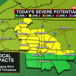


A cold front will bring the threat of strong to severe storms to the region Monday afternoon. Temps will climb into the upper 70s today under partly cloudy skies. The more sunshine we get the greater the chance of stronger storms this afternoon. The biggest threat will be damaging wind gusts, but an isolated tornado can’t be ruled out – especially for the foothills and Piedmont as the boundary passes through during peak daytime heating.

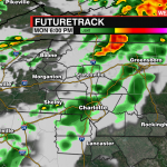
Storms will begin around 2 pm for the mountains.

Scattered storms will move into the I-85 corridor from 4 pm to 7 pm. This will be when the threat for severe storms will be greatest.

Storms will clear the region by 8-9 pm.

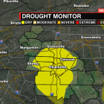
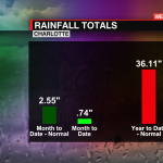
This boundary will move through quickly, so today won’t be a washout. Rainfall totals are down more than 1.5″ for the month and more than 4″ for the year. Our drought monitor shows abnormally dry conditions for much of the Piedmont so rain is needed for the area. Another opportunity for a good soaking rain will return Thursday.

Download the WCCB Weather App Powered by COIT for the latest information from our WeatherWise team.


