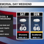
Cool, Cloudy, Breezy & Wet Memorial Day Weekend Across The Carolinas
Saturday will be the worst of all the days, but expect showers through the weekend

CHARLOTTE, NC — An area of low pressure to our southeast and an area of high pressure to our north will make for a nasty day weekend across the Carolinas.
WEEKEND FORECAST OVERVIEW:
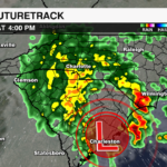
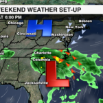
The amount of rain we see will depend on the track of the low pressure. Saturday looks to be the worst day. IF the low tracks over us on Sunday, most of the widespread rain will be north of Charlotte. We would still see scattered showers, but it will not be as widespread as Sunday. By Monday, rain chances stick around, but more widely scattered.
TROPICAL DEVELOPMENT:
Tropical development is unlikely, but the National Hurricane Center is giving this a low 10% chance of development. Regardless of development, this low pressure will bring rain, wind, rough surf and a high rip current risk to the beaches along with impacts to our area.
TIMING:
- Saturday will be the worst of all the days, but expect showers through the weekend
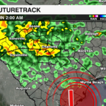
- Showers on Sunday will likely be scattered. Some model guidance as of Thursday evening shows dry air trying to wrap around the low. This would lead to rain being more scattered.
- Monday rain chances will be the lowest of the three days, but still widely scattered
IMPACTS:
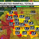
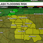
- 2-3” of rain could lead to isolated flooding
- Wind gusts up to 35 mph


TEMPERATURES:
- Roughly 20 degrees below average. Temperatures will struggle to reach 60 on Saturday.
BEACH FORECAST:
- Rain, wind, high rip current risk and rough seas along the east coast.
- Tap here to read more on rip currents and how to escape one.