Strong to Severe Storms Possible Across the Region Monday
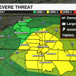
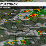
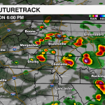
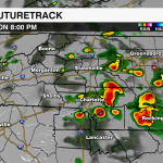
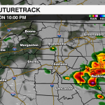
An approaching cold front will trigger scattered to numerous showers and thunderstorms this afternoon. A few of these storms could become strong to severe. The Storm Prediction Center has issued a Slight Risk (Level 2 out of 5) for much of the region south of I-40.

Breaks in the cloud cover will allow temperatures to climb into the mid-80s today. Tropical moisture has returned to the region as well with dew points back near 70. This will provide plenty of fuel for any afternoon storms that develop. Strong shear is also a player today signaling a few supercells will be possible.
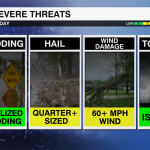
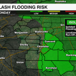
The biggest concern remains damaging straight-line wind and large hail. However, due to the location of the surface, a few storms will likely be rotating which means there will be a low-end tornado threat this afternoon – especially for areas near and south of I-85. These storms will also be able to produce heavy downpours, so localized flooding is also a concern.
WHERE:
South of I-40
WHEN:
4PM – 10PM
THREATS:
Damaging wind & large hail are the main concerns, but an isolated tornado cannot be ruled out. Localized flooding will also need to be monitored.

The cold front will settle south of the region Tuesday. High pressure to our north will lock in clouds and keep temps well below average through much of the week.
Keep track of the storms with the WeatherWise team by downloading the WCCB Weather App Powered by COIT.