Clouds & Rain Chances Build
We'll take whatever we can get, but no drought-busting rain is in our immediate future.
Happy Hump Day! After bright skies carried us through the past few days, we’re flipping the weather script as we head into the back half of the week. We’ll be hard-pressed to see much sunshine today as overcast conditions dominate the Carolinas. Highs will be stuck in the 50s and lower 60s for most. Despite the darker skies, rain chances largely remain at bay until Thursday evening. We’ll take whatever we can get at this point, but don’t expect drought-busting rain anytime soon. A few showers may roll through our area late Thursday into early Saturday; most communities will receive under a tenth of an inch, if anything at all.
The weekend is looking wonderful. Highs will top out near 70° on Saturday in the Queen City as sunshine regains its foothold in the Carolinas. Cooler air arrives by Sunday behind the front that passes through on Friday. The start of next week will be interesting. Model guidance shows another wedge sets up by Monday as a rainmaking system develops in the northern Gulf. If it were January or February, we could be talking snow and ice as moisture arrives by Tuesday. For now, a chilly rain looks more likely for the Piedmont with marginal wintry precipitation possible for higher elevations.
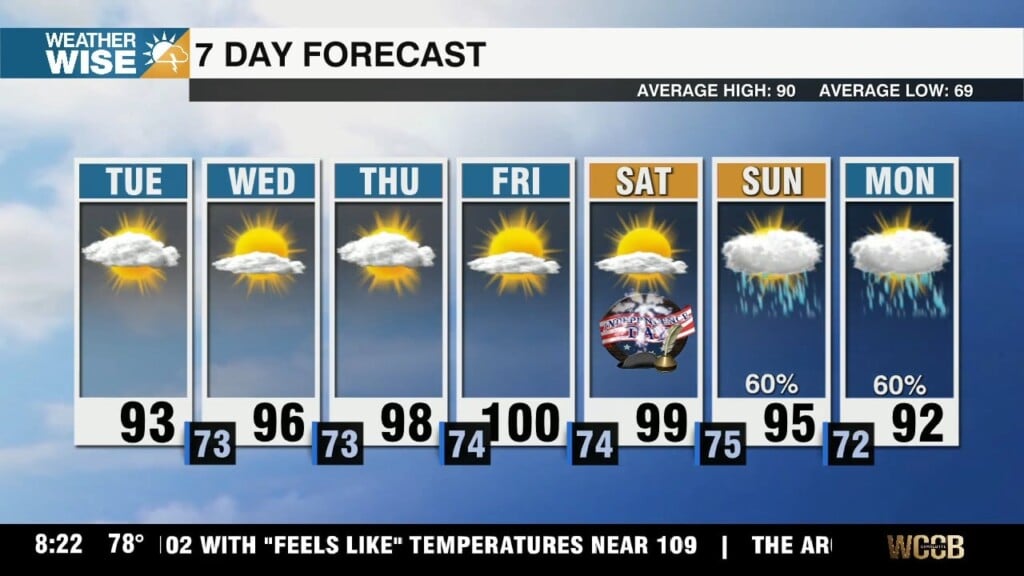
Today: Cloudy and cool. High: 59°. Wind: NE 5-10.
Tonight: Mostly cloudy. Low: 46°. Wind: NE 5-10.
Thursday: AM mostly cloudy. PM mostly sunny. High: 68°. Wind: NE 5-10.
Thursday Night: Variable clouds. Stray shower? Low: 55°. Wind: NE 5-10.
Friday: Mostly cloudy with a few showers. High: 68°. Wind: NE 5-10.