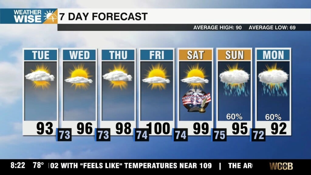
Frigid Stretch Ahead
Despite abundant sunshine, highs remain 5-10° below average through midweek.
It’s beginning to feel a lot like Christmas. Above-average temperatures have dominated much of November thus far, but the month is poised to end on a chilly note. A powerful ridge of high pressure to our northwest will pump frigid air into the Carolinas through midweek. Highs will struggle to clear the 30s and 40s across the WCCB Charlotte viewing area within this timeframe. A few snow showers are possible in the High Country this and Tuesday morning as northwesterly flow strains out any leftover moisture from last weekend’s front over the mountains. Precipitation chances in the Foothills and Piedmont will hit rock bottom over the next three days.
Our next shot at meaningful rainfall comes by the second day of December. An area of low pressure will develop east of the Rockies by midweek, picking up moisture from the Gulf as it sweeps eastward. Shower chances will begin to pick up late on Friday, but there is significant model disagreement on how much rain we’ll see. Regardless, temperatures will rise heading into the weekend before a second rainmaking system arrives by Sunday. Highs should return to above-normal values in the 50s and 60s this coming weekend.
Monday: Chilly sunshine. High: 55°. Wind: NW 5-15.
Monday Night: Clear and cold. Low: 28°. Wind: NW 5-10.
Tuesday: Another brisk day. High: 50°. Wind: NW 5-15. Gusts: 20+
Tuesday Night: Freezing cold. Low: 24°. Wind: N 5-10.
Wednesday: Sunny. Remaining cold. High: 50°. Wind: SW 5-10.