Tracking Future Imelda and Possible Carolina Impacts
IF the Carolinas see impacts, they would come early next week.
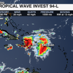
TROPICAL UPDATE – Thursday, September 25:
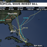
A tropical wave located near the Turks and Caicos Islands is producing showers and thunderstorms. An area of low pressure is expected to form along the wave by Friday. That low pressure is then forecast to become organized and develop into a tropical depression. This system is currently being called invest 94-L, but could soon become Imelda. While this forecast is not etched in stone, we have not liked the trends. Models have been trending toward a Carolina landfall early next week.
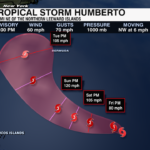
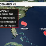
SCENARIO 1 – IF Imelda moves quickly and Humberto slows down, there will likely be no interaction between the two. This is the scenario that will take it toward the Carolinas. 
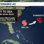
SCENARIO 2 – Imelda and Humberto interact and Humberto slingshots Imelda out to sea. Of course this is what we hope for.
TIMING – Early next week.
IMPACTS – It is too soon for specifics.
The WCCB Weather team will keep you updated on-air and online.