Summer Strikes Back, Laura Lashes Louisiana
Highs should top out in the 80s and 90s for the next few days before the rain returns by the weekend.
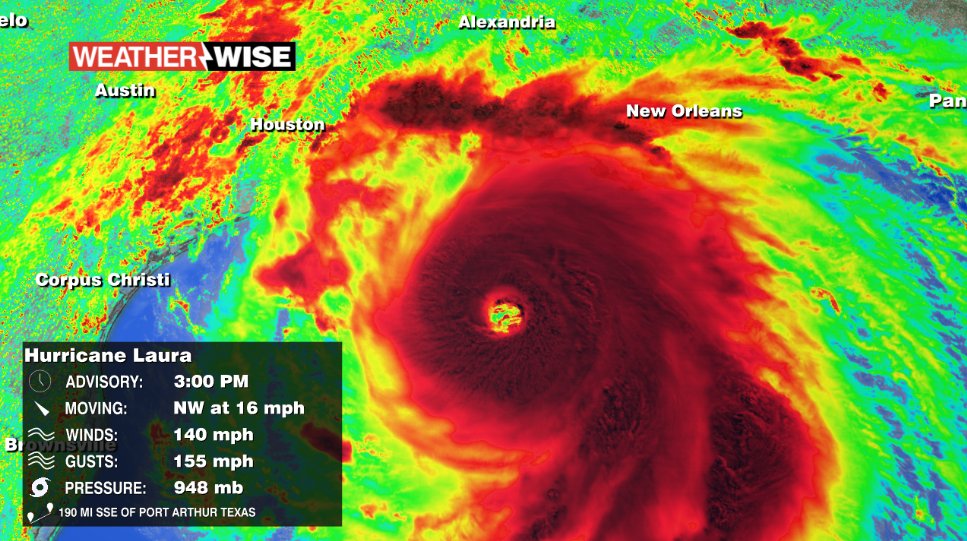
The clouds have finally parted across the Carolinas, allowing for abundant sunshine and above-normal temperatures to return to our area. Expect shower and storms chances to remain minimal at-best as highs jump up in the 90s for the Piedmont, while the Foothills and High Country warm into the 80s. The sunshine won’t last very long, though, as current Hurricane Laura pounds the Gulf Coast. While we certainly won’t see impacts as bad as those to be felt in Louisiana, we could be in for quite a messy Saturday. The bulk of the storm should remain to our north, but gusty winds and occasional heavy rain could pelt the WCCB Charlotte viewing area for the first half of the weekend. Despite the rain on the way, temperatures should hover around 90º through the start of next week.
Tonight: A few clouds. Low: 72º. Wind: Light.
Thursday: Mainly sunny. High: 92°. Wind: SW 5-10.
Thursday Night: Clouds begin to build. Low: 74°. Wind: Light.
Friday: Mostly cloudy. Shower/storm chance late. High: 92°. Wind: SW 5-15.