WeatherWise Alert: severe storms likely today in Charlotte area
Gusty winds and significant hail are the main threats Thursday afternoon and evening, but a quick spin-up tornado can't be ruled out.
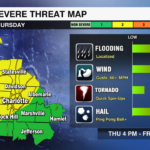
A stormy setup is taking shape across the Carolinas today. Strong to severe storms are expected to fire up by late afternoon, bringing the potential for large hail, damaging wind, isolated tornadoes and locally heavy rain to the Charlotte region.

Main Threats Today:
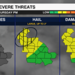
- Large hail (up to 2″ in diamter, or hen egg size, especially near the mountains)
- Damaging wind gusts (especially with evening clusters)
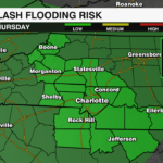
- Localized flooding (possible where storms train)
- Isolated tornado? Low risk, but not zero

Storm Evolution & Timeline:
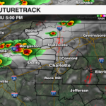
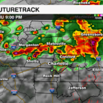
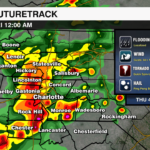
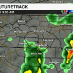
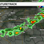
Afternoon (4–8 PM): Isolated storms form over the mountains and foothills. Some may become supercells, with large hail and damaging wind.
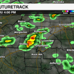
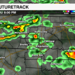
Evening (6–10 PM): Storms spread south and east, organizing into clusters or a broken line as they move into the Piedmont, including Charlotte.
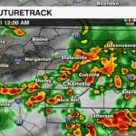
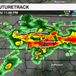
Late Night (10 PM–4 AM): Storms continue south and east with heavy rain and gusty winds as the front slowly pushes in.
Why This Is Happening:
A potent upper-level disturbance is moving through the Ohio and Tennessee Valleys, pulling energy and shear across the Carolinas. Meanwhile, surface heating and increasing mid-level lapse rates are priming the atmosphere for severe storm development. Although the cold front itself doesn’t arrive until Friday, the combination of upper-level lift and instability ahead of it is enough to fuel today’s severe threat.
Looking Ahead:
Friday: Scattered showers/storms possible again, but less intense.
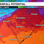
Weekend: Cooler temps. Saturday looks mostly dry. Rain returns Sunday into early next week with a cold-air damming wedge setting up.
Previous Update Wed 5/7
No rest for the weary. After a robust storm system brought heavy rain, gusty winds, hail, and an EF-0 tornado to the WCCB Charlotte viewing area last weekend, we’re under the severe weather gun again as we close out the workweek.

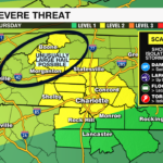
A Level 2 (out of 5) risk for severe weather has been posted for much of the Metro along I-85 and points northwest between Thursday afternoon and Friday morning. A Level 1 risk is in effect for areas southeast of I-85 for the same timeframe.
TIMING

Much like what we saw last weekend, isolated storms Thursday afternoon will increase in both coverage and overall severe heading into the evening and overnight hours. While the severe threat ends shortly after midnight, rain chances linger well into Friday.


A Level 1 risk for severe weather has also been posted for much of the WCCB Charlotte viewing area on Friday as another line of storms develops in the afternoon. There is significant disagreement amongst short-range models as to how strong/widespread these storms may be, but we’ll want to stay weather-wise before calmer conditions arrive by the weekend.
MAIN THREATS
While most cells on Thursday will be non-severe, the heaviest storms will pack gusty winds up to 60 mph, hail approaching the size of ping-pong balls, and localized torrential rainfall. While the tornado threat is very low – much like last weekend – we’ll still need to watch for quick spin-ups, especially after sunset.
BOTTOMLINE
This looks like a very similar setup to what happened last weekend – isolated afternoon storms becoming more scattered heading into the night. Once again, the main threats will be significant hail and gusty winds. The tornado threat is very low, but as we learned last weekend, a quick spin-up isn’t out of the question. Stay weather-wise and keep your phones charged Thursday night in case any warnings are issued.